
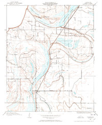
1908 Map of Dundee
USGS Topo · Published 1957About this map
The Yazoo and Mississippi Delta at the beginning of the twentieth century is defined here by its complex drainage network and early rail infrastructure. The Yazoo and Mississippi Valley R R forms the primary north-south corridor, connecting the settlements of Clayton, Maud, and Dundee. This landscape is heavily shaped by its oxbow lakes and brakes, leftovers of an older river course, such as Beaverdam Lake, Kyles Brake, and Cypress Lake. The influence of the Tallahatchie Drainage Commission is evident in the systematic surveying of this low-lying territory. Small community hubs like Cockes Store and Oakgrove Church serve the rural population, while Lake School provides a central educational point for the surrounding farmsteads. The inclusion of Fortyfour Road highlights early overland transportation routes in a region primarily defined by its bayous and brakes.
Find a feature on this map
20 named features on this map. Tap any name to fly to it.
Don’t see what you’re looking for? This feature index may not catch every label — zoom into the map to look around manually.
Map Details
Editions of this 1908 Dundee Map
2 editions found
Other maps of this area

1908 · Lula
USGS Topo · 1:24,000

1908 · Hollywood
USGS Topo · 1:24,000

1908 · Moon Lake
USGS Topo · 1:24,000

1908 · Walnut Lake
USGS Topo · 1:24,000

1910 · Dundee
USGS Topo · 1:31,680

1910 · Walnut Lake
USGS Topo · 1:31,680

1912 · Moon Lake
USGS Topo · 1:31,680

1912 · Lula
USGS Topo · 1:31,680

1913 · Hollywood
USGS Topo · 1:31,680

1932 · Marks
USGS Topo · 1:48,000