
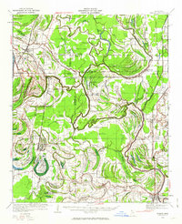
1932 Map of Marks
USGS Topo · Published 1932About this map
The Coldwater River carves a complex, winding path through this Mississippi Delta landscape, defining the boundaries and agricultural rhythms of the early 1930s. The region is densely populated with community centers, featuring a remarkable concentration of local landmarks like Swan Lake Normal College and family-named schools such as Cammack Sch and Lula Rich Sch. Transportation is anchored by the Yazoo and Mississippi Valley Railroad, which connects the larger settlements of Marks and Lula.
Find a feature on this map
122 named features on this map. Tap any name to fly to it.
Don’t see what you’re looking for? This feature index may not catch every label — zoom into the map to look around manually.
Map Details
Editions of this 1932 Marks Map
2 editions found
Other maps of this area

1908 · Lula
USGS Topo · 1:24,000

1908 · Dundee
USGS Topo · 1:24,000

1908 · Coahoma
USGS Topo · 1:24,000

1908 · Moon Lake
USGS Topo · 1:24,000

1908 · Jonestown
USGS Topo · 1:24,000

1908 · Walnut Lake
USGS Topo · 1:24,000

1910 · Dundee
USGS Topo · 1:31,680

1910 · Coahoma
USGS Topo · 1:31,680

1910 · Walnut Lake
USGS Topo · 1:31,680

1910 · Jonestown
USGS Topo · 1:31,680