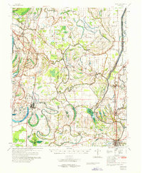
1970 Map of Marks
USGS Topo · Published 1970About this map
Marks and the surrounding Delta landscape of Quitman County and Tunica County are defined here by a dense network of bayous, lakes, and small agricultural settlements. The Coldwater River snakes through the center of the sheet, surrounded by numerous Oxbow features like Lula Lake and Moon Lake. This 1970 snapshot of the region shows a landscape heavily shaped by its water and rail connections, with the Illinois Central railroad line providing the backbone for towns such as Lula, Jonestown, and Belen. Local life is anchored by a remarkable number of country churches and community centers, from Dickerson Chapel and Macedonia Chapel to the Lula-Rich Academy. Notable archaeological landmarks like Indian Mound and Posey Mound rise above the flat alluvial terrain, while several Fish Farm operations and a Landing Strip indicate the area's mid-century economic activities and infrastructure development.
Find a feature on this map
101 named features on this map. Tap any name to fly to it.
Don’t see what you’re looking for? This feature index may not catch every label — zoom into the map to look around manually.
Map Details
Editions of this 1970 Marks Map
This is the sole edition of this map. No revisions or reprints were ever made.
Other maps of this area

1908 · Lula
USGS Topo · 1:24,000

1908 · Dundee
USGS Topo · 1:24,000

1908 · Coahoma
USGS Topo · 1:24,000

1908 · Moon Lake
USGS Topo · 1:24,000

1908 · Jonestown
USGS Topo · 1:24,000

1908 · Walnut Lake
USGS Topo · 1:24,000

1910 · Dundee
USGS Topo · 1:31,680

1910 · Coahoma
USGS Topo · 1:31,680

1910 · Walnut Lake
USGS Topo · 1:31,680

1910 · Jonestown
USGS Topo · 1:31,680