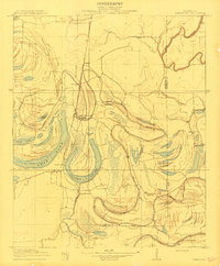
1910 Map of Jonestown
USGS Topo · Published 1910About this map
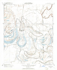
Jonestown serves as the focal point for this 1908 survey, situated at the intersection of a intricate hydrological landscape and the vital Yazoo and Mississippi Valley RR. The terrain is dominated by the serpentine remnants of old river courses, manifesting as oxbows and swampy depressions known locally as brakes. Significant water features like Swan Lake, Alcorn Brake, and Hull Brake illustrate the shifting nature of the Delta's geography before modern drainage fully reshaped the region.
Find a feature on this map
22 named features on this map. Tap any name to fly to it.
Don’t see what you’re looking for? This feature index may not catch every label — zoom into the map to look around manually.
Map Details
Editions of this 1910 Jonestown Map
This is the sole edition of this map. No revisions or reprints were ever made.
Historical Maps of Jonestown Through Time
8 maps found