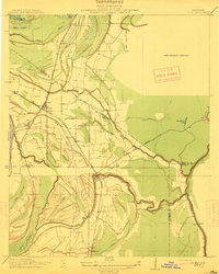
1912 Map of Lula
USGS Topo · Published 1912About this map
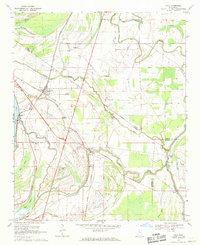
The Tallahatchie Drainage Commission collaborated on this 1912 study of the Mississippi Delta’s intricate hydrology, centered on the junction of the Yazoo and Mississippi Valley R. R. and its Helena Branch. The settlement of Lula serves as the focal point, situated amidst a landscape defined by old oxbows and swampy breaks. The map captures the industrial character of the era through the Stempson Lumber Company R. R., which pushes through the Muddy Bayou lowlands. Further south, the community of Rich sits near the winding Yazoo Pass, reflecting a time when drainage projects were beginning to reshape the fertile but flood-prone bottomlands of Coahoma and Tunica counties. The intricate topography reveals the transition from natural wetlands like Carr Brake to agricultural settlements such as Roseacres and Wildwood.
Find a feature on this map
30 named features on this map. Tap any name to fly to it.
Don’t see what you’re looking for? This feature index may not catch every label — zoom into the map to look around manually.
Map Details
Editions of this 1912 Lula Map
This is the sole edition of this map. No revisions or reprints were ever made.
Historical Maps of Lula Through Time
8 maps found