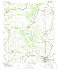
1969 Map of Marks
USGS Topo · Published 1971About this map
Ancient earthworks such as Indian Mound and Posey Mound sit within the bends of the Coldwater River, signaling a long history of human habitation in this part of the Delta. The 1969 landscape is defined by its intricate drainage patterns, where the river winds past Clear Lake and Bear Lake toward the settlement of Marks. The local economy and social structure are visible through the dense placement of rural churches and cemeteries, including Eagle Grove Ch and Gleason Grove Cem. The presence of the Indian Treaty Boundary cutting across the northern sections provides a significant historical anchor for property research. Transport and commerce are anchored by the Illinois Central railroad, which links the small communities of Darling, Essex, and Hinchcliff along the eastern corridor of Burrell Bayou.
Find a feature on this map
37 named features on this map. Tap any name to fly to it.
Don’t see what you’re looking for? This feature index may not catch every label — zoom into the map to look around manually.
Map Details
Editions of this 1969 Marks Map
This is the sole edition of this map. No revisions or reprints were ever made.
Other maps of this area

1908 · Lula
USGS Topo · 1:24,000

1908 · Jonestown
USGS Topo · 1:24,000

1910 · Jonestown
USGS Topo · 1:31,680

1912 · Lula
USGS Topo · 1:31,680

1932 · Sledge
USGS Topo · 1:48,000

1932 · Tutwiler
USGS Topo · 1:48,000

1932 · Marks
USGS Topo · 1:48,000

1935 · Crowder
USGS Topo · 1:62,500

1935 · Marks
USGS Topo · 1:62,500

1935 · Tutwiler
USGS Topo · 1:62,500