
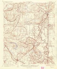
1935 Map of Tutwiler
USGS Topo · Published 1935About this map
Cassidy Bayou winds through a dense network of delta lowlands, defining a landscape dominated by intricate watercourses and scattered agricultural settlements in the mid-1930s. The regional economy centers on the Yazoo and Mississippi Valley railroad, which connects hubs like Tutwiler and Lambert to the surrounding plantations and the State Farm prison facility at Camp A and Camp B. The abundance of local institutions—from Holly Grove Ch and St Elmo Chapel to numerous rural schoolhouses like Graham Sch and Miller Sch—illustrates the social fabric of the Mississippi Delta during this era. Land use is deeply tied to the natural drainage, with features such as Beaver Ruin Brake and Buckskin Lake interspersed between the high ground used for cotton farming and the Yazoo River basin.
Find a feature on this map
79 named features on this map. Tap any name to fly to it.
Don’t see what you’re looking for? This feature index may not catch every label — zoom into the map to look around manually.
Map Details
Editions of this 1935 Tutwiler Map
2 editions found
Other maps of this area

1908 · Coahoma
USGS Topo · 1:24,000

1908 · Jonestown
USGS Topo · 1:24,000

1910 · Coahoma
USGS Topo · 1:31,680

1910 · Jonestown
USGS Topo · 1:31,680

1931 · Sumner
USGS Topo · 1:48,000

1931 · Drew
USGS Topo · 1:48,000

1932 · Sledge
USGS Topo · 1:48,000

1932 · Philipp
USGS Topo · 1:48,000

1932 · Tutwiler
USGS Topo · 1:48,000

1932 · Marks
USGS Topo · 1:48,000