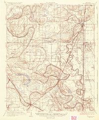
1935 Map of Tutwiler
USGS Topo · Published 1935About this map
Tutwiler and Lambert anchor this Delta landscape at a time when the Yazoo and Mississippi Valley Railroad and a dense network of bayous defined local commerce and movement. The map captures a transition in land use, showing the State Farm complex and numerous rural congregations like Mt Moriah Ch and St Elmo Chapel. The intricate drainage of the region is evident in the winding courses of Cassidy Bayou and Deadwater Bayou, punctuated by features like Buckskin Lake and Beaver Ruin Brake. This survey provides a window into the plantation-era settlement patterns of the mid-1930s, where small schools like Philadelphia Sch and Graham Sch served dispersed agricultural communities. The topography reveals the complex hydrology of the Yazoo Bayou basin before modern flood control altered many of these seasonal wetlands and brakes.
Find a feature on this map
80 named features on this map. Tap any name to fly to it.
Don’t see what you’re looking for? This feature index may not catch every label — zoom into the map to look around manually.
Map Details
Editions of this 1935 Tutwiler Map
2 editions found

Other maps of this area

1908 · Coahoma
USGS Topo · 1:24,000

1908 · Jonestown
USGS Topo · 1:24,000

1910 · Coahoma
USGS Topo · 1:31,680

1910 · Jonestown
USGS Topo · 1:31,680

1931 · Sumner
USGS Topo · 1:48,000

1931 · Drew
USGS Topo · 1:48,000

1932 · Sledge
USGS Topo · 1:48,000

1932 · Philipp
USGS Topo · 1:48,000

1932 · Tutwiler
USGS Topo · 1:48,000

1932 · Marks
USGS Topo · 1:48,000