Old Maps of Tunica County, Mississippi
Explore 153 old maps of Tunica County, spanning from 1908 to today. These high-resolution historic maps reveal how streets, neighborhoods, landmarks, and natural features evolved over time — perfect for genealogy, metal detecting, research, and local history exploration.
What you can do with these maps:
- See how Tunica County changed over time: Compare historical maps to modern-day views to trace roads, homesites, rail lines & more.
- View detailed metadata: Each map includes creators, publishers, year, scale, and archive source.
- Overlay maps with satellite & LiDAR: Visualize the past alongside modern tools to explore terrain & human change.
- Trusted historical sources: Maps sourced from the USGS, Library of Congress, and other archives.
- Access maps your way: View online, download high-res files, or order prints for personal or research use.
Start exploring old maps of Tunica County to uncover forgotten places, hidden landmarks, and the deep history beneath your feet.
Tunica County, MS maps
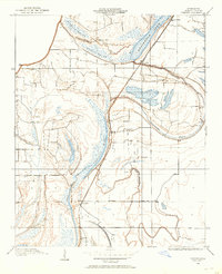
(153)- 1908 Map of Lula, 1957 Print
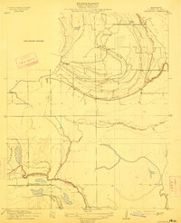
 1908 Lula1957 Print · USGSThe Mississippi Delta at the start of the twentieth century is defined here by the meeting of rail and river near Lula. Genealogists and historians can trace the early layout of settlements like Rich, Mascot, and Birdie along the various branches of the Yazoo and Mississippi Valley R. R.
 - 1908 Map of Dundee, 1957 Print
 1908 Dundee1957 Print · USGSMississippi Delta life in the early 1900s centered on the rail lines and fertile lowlands of Tunica County. Researchers can trace the layout of small settlements like Dundee and Maud or locate landmarks such as Oakgrove Church and Cockes Store along the Bayou.2 unique versions available
 - 1908 Map of Hollywood, 1961 Print
 1908 Hollywood1961 Print · USGSTunica County at the dawn of the twentieth century was a land of intricate bayous and rural sanctuaries. Genealogists and researchers can trace early congregation sites like Corinth Church and Moon Chapel alongside the winding Minton Bayou.
 - 1908 Map of Moon Lake, 1961 Print
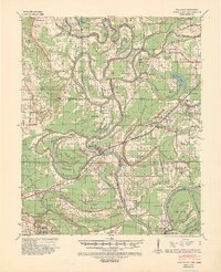
 1908 Moon Lake1961 Print · USGSThe Mississippi Delta's oxbows and bayous are meticulously detailed here in the early 1900s, showing a river-driven landscape. Trace the old rail lines of the Yazoo and Mississippi Valley R R or locate local centers like Delta Gerald P O and Powell.
 - 1908 Map of Walnut Lake, 1961 Print
 1908 Walnut Lake1961 Print · USGSThe Mississippi Delta's shifting waters and early settlements are captured here in the decade before the First World War. Genealogists and researchers can trace the locations of Walnut Lake School, Gerbach Mill, and local hubs like Dubbs.
 - 1910 Map of Dundee
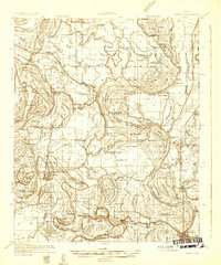
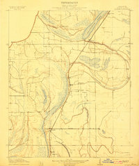 1910 Dundee1910 Print · USGSTunica County at the peak of the Delta rail era is captured here, centered on the Yazoo and Mississippi Valley R. R. corridor. Researchers can trace family-named sites like Cockes Store and old community hubs including Oakgrove Church and Dundee.
 - 1910 Map of Walnut Lake
 1910 Walnut Lake1910 Print · USGSThe Mississippi Delta's winding waterways and early drainage districts are meticulously detailed in this early twentieth-century survey. Trace the family names and rural hubs of Tunica and Quitman Counties, locating landmarks like Walnut Lake School, Gerlach Mill, and the settlement of Pink.
 - 1912 Map of Moon Lake
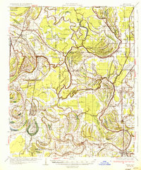
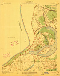 1912 Moon Lake1912 Print · USGSThe Mississippi Delta's intricate river-and-rail landscape is preserved here during the early twentieth century. Genealogists and local historians can trace the foundations of the area through the Yazoo and Mississippi Valley R R and rural settlements like Powell and Delta Gerald P O.3 unique versions available
 - 1912 Map of Lula
 1912 Lula1912 Print · USGSThe Mississippi Delta at the start of the twentieth century shows a landscape defined by lumber rails and oxbow lakes. Trace the early growth of Lula and Rich along the Yazoo and Mississippi Valley R. R. and the winding Yazoo Pass.
 - 1913 Map of Hollywood
 1913 Hollywood1913 Print · USGSTunica County at the dawn of the twentieth century was a landscape of intricate Delta bayous and isolated community churches. Genealogists and historians can trace the early locations of Corinth Church, New Hope Church, and water landmarks like Jasper Lake.
 - 1931 Map of Horseshoe Lake
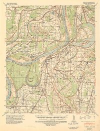
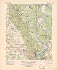
 1931 Horseshoe Lake1931 Print · USGSThe Mississippi Delta's shifting landscape is captured here in the early thirties, centered on the great oxbow of Horseshoe Lake. Genealogists and historians can trace family-named tracts like the Tucker Plantation and Seyppel Plantation, alongside rural landmarks like the Y M C A Camp and Robinsonville.
 - 1932 Map of Horn Lake
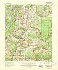
 1932 Horn Lake1932 Print · USGSNorthwest Mississippi and the river border come alive in the 1930s as the rail lines and river landings shaped local life. Genealogists can trace family footprints at Howards Store, Bynums Chapel, and Sunrise Sch and Ch near the banks of Horn Lake.3 unique versions available
 - 1932 Map of Marks
 1932 Marks1932 Print · USGSThe Mississippi Delta in the early 1930s is a landscape of complex bayous and tight-knit rural communities. Genealogists can trace family roots through numerous local landmarks like Swan Lake Normal College, Robinson Chapel, and the Yazoo and Mississippi Valley Railroad.2 unique versions available
 - 1932 Map of Crenshaw, 1964 Print
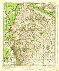
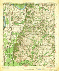
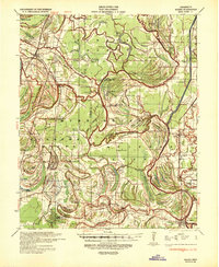
 1932 Crenshaw1964 Print · USGSNorthwest Mississippi in the early thirties reveals a complex network of Delta bayous and hill-country settlements. Genealogists can trace family roots through dozens of rural landmarks, from Cottonville Store to Brooks Chapel and the Longtown Sch.
 - 1935 Map of Marks
 1935 Marks1935 Print · USGSThe Mississippi Delta landscape of the 1930s is captured here in rich detail, showcasing a network of bayous and rail towns. Genealogists can locate family landmarks like Swan Lake College, Macedonia Chapel, and the Posey Mound near Jonestown.2 unique versions available
 - 1935 Map of Crenshaw
 1935 Crenshaw1935 Print · USGSNorthwest Mississippi in the mid-thirties was a landscape of intricate bayous and thriving rural communities tied to the rail and river. Genealogists can trace family roots through numerous local landmarks like Cottonville Store, New Salem Ch, and Spring Hill Sch.2 unique versions available
 - 1935 Map of Horn Lake
 1935 Horn Lake1935 Print · USGSThe Mississippi Delta and Tennessee borderlands meet here in the mid-1930s, showing a landscape of bluff-top farms and river-bottom bayous. Genealogists can trace family roots through dozens of local landmarks like Morning Star Ch, Eudora, and Sunrise Sch.2 unique versions available
 - 1939 Map of Clayton, 1941 Print
 1939 Clayton1941 Print · USGSTunica County and the Mississippi Delta are shown here during the pre-war years, revealing a rural landscape shaped by river bends and rail lines. Genealogists can trace family names through dozens of community landmarks like Reed Normal Sch, Oakwood Cem, and Hamlin Ch.2 unique versions available
 - 1939 Map of Farrell, 1941 Print
 1939 Farrell1941 Print · USGSThe Mississippi Delta riverfront at Friar Point is captured here in the years before the Second World War. Researchers can trace family sites like Preston Places and Stovall or locate old rural centers including McLemore Sch and Llewellyn Ch & Sch.2 unique versions available
 - 1939 Map of Horseshoe Lake, 1941 Print
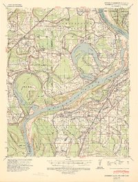 1939 Horseshoe Lake1941 Print · USGSThe oxbows and plantations of the Mississippi delta are captured here in the late thirties as the river redefines state boundaries. Genealogists can locate named homesteads and community centers like the Abbey Leatherman Plantation, Robinsonville, and the Hopewell Sch & Ch.2 unique versions available
 - 1939 Map of Park Place, 1941 Print
 1939 Park Place1941 Print · USGSThe Arkansas delta near the St. Francis and L'Anguille Rivers is shown here in the late 1930s as a thriving rail and river landscape. Genealogists can locate family names and rural centers like True Love Bar Ch & Sch, Rollinson, and the Marianna Helena Land Project.2 unique versions available
 - 1939 Map of Marks, 1943 Print
 1939 Marks1943 Print · USGSThe Mississippi Delta era is preserved here just before the war, showing a landscape defined by the Coldwater River and the Yazoo and Mississippi Valley RR. Genealogists can trace local roots at Swan Lake College, Belen, and Strangers Rest Ch.
 - 1939 Map of Latour, 1944 Print
 1939 Latour1944 Print · USGSPhillips County and the Mississippi Delta are shown here just before the Second World War as a landscape defined by river navigation and rail transport. Researchers can trace the footprints of communities like Helena and find family-named landmarks such as Tate Ldg, Zion Ch, and Flower Chapel Cemetery.2 unique versions available
 - 1948 Map of Helena
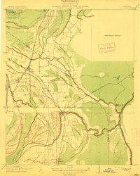
 1948 Helena1948 Print · USGSEastern Arkansas and the Mississippi Delta are captured here just after the war, showing a landscape defined by its great rivers and rail lines. Genealogists can trace family locations near Bemis Plantation, Helena, and smaller rail stops like Wheatley and Moro.
 - 1950 Map of Helena
 1950 Helena1950 Print · USGSMid-century Phillips County and the surrounding Delta region are shown at a peak of rail and river commerce. Genealogists and historians can trace family locations through numerous rural communities like Old Austin, Cotton Plant, and West Helena, or follow the routes of the Missouri Pacific RR across Grand Prairie.2 unique versions available
Showing maps 1-25 of 153
Top cities of Tunica County
Frequently asked questions
- What are the different types of historical maps available for Tunica County?
- What is the oldest map of Tunica County?
- Where can I purchase historical maps of Tunica County for my home or office?
- Where can I download high-res historical maps of Tunica County?
- Are there historical topographic maps available for Tunica County?
- Is there historical aerial imagery available for Tunica County?
- Where are historical maps of Tunica County sourced from?