1900-1909 Maps of Tunica County, Mississippi
Explore 5 historic maps of Tunica County from 1900-1909. These maps offer a rare glimpse into what life looked like during the 1900s — showing old roads, neighborhoods, homes, and landmarks that have changed or disappeared over time.
Whether you're researching your family's past, planning a metal detecting trip, or studying how Tunica County's landscape evolved across the 1900s, these high-resolution maps are a powerful tool for exploring the history of this region.
- Focus on a specific era: All maps on this page are from the 1900s, giving you a focused view of this time period.
- See what’s changed: Compare century-old streets, trails, and buildings to today's modern landscape using overlays and satellite layers.
- Research with precision: Use these maps for genealogy, historical research, land use analysis, or educational projects.
- View, download, or print: Maps are fully viewable online in high resolution, and can be downloaded or printed for your own records.
Start exploring Tunica County's history through authentic maps from the 1900s. This is your window into the past.
Tunica County, MS maps
(5)- 1908 Map of Lula, 1957 Print
 1908 Lula1957 Print · USGSThe Mississippi Delta at the start of the twentieth century is defined here by the meeting of rail and river near Lula. Genealogists and historians can trace the early layout of settlements like Rich, Mascot, and Birdie along the various branches of the Yazoo and Mississippi Valley R. R.
 - 1908 Map of Dundee, 1957 Print
 1908 Dundee1957 Print · USGSMississippi Delta life in the early 1900s centered on the rail lines and fertile lowlands of Tunica County. Researchers can trace the layout of small settlements like Dundee and Maud or locate landmarks such as Oakgrove Church and Cockes Store along the Bayou.2 unique versions available
 - 1908 Map of Hollywood, 1961 Print
 1908 Hollywood1961 Print · USGSTunica County at the dawn of the twentieth century was a land of intricate bayous and rural sanctuaries. Genealogists and researchers can trace early congregation sites like Corinth Church and Moon Chapel alongside the winding Minton Bayou.
 - 1908 Map of Moon Lake, 1961 Print
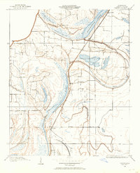
 1908 Moon Lake1961 Print · USGSThe Mississippi Delta's oxbows and bayous are meticulously detailed here in the early 1900s, showing a river-driven landscape. Trace the old rail lines of the Yazoo and Mississippi Valley R R or locate local centers like Delta Gerald P O and Powell.
 - 1908 Map of Walnut Lake, 1961 Print
 1908 Walnut Lake1961 Print · USGSThe Mississippi Delta's shifting waters and early settlements are captured here in the decade before the First World War. Genealogists and researchers can trace the locations of Walnut Lake School, Gerbach Mill, and local hubs like Dubbs.
End of results
Showing maps 1-5 of 5
Top cities of Tunica County
Frequently asked questions
- What are the different types of historical maps available for Tunica County?
- What is the oldest map of Tunica County?
- Where can I purchase historical maps of Tunica County for my home or office?
- Where can I download high-res historical maps of Tunica County?
- Are there historical topographic maps available for Tunica County?
- Is there historical aerial imagery available for Tunica County?
- Where are historical maps of Tunica County sourced from?