1970s Maps of Tunica County, Mississippi
Explore 8 historic maps of Tunica County from the 1970s. These maps offer a rare glimpse into what life looked like during the 1970s — showing old roads, neighborhoods, homes, and landmarks that have changed or disappeared over time.
Whether you're researching your family's past, planning a metal detecting trip, or studying how Tunica County's landscape evolved across the 1970s, these high-resolution maps are a powerful tool for exploring the history of this region.
- Focus on a specific era: All maps on this page are from the 1970s, giving you a focused view of this time period.
- See what’s changed: Compare century-old streets, trails, and buildings to today's modern landscape using overlays and satellite layers.
- Research with precision: Use these maps for genealogy, historical research, land use analysis, or educational projects.
- View, download, or print: Maps are fully viewable online in high resolution, and can be downloaded or printed for your own records.
Start exploring Tunica County's history through authentic maps from the 1970s. This is your window into the past.
Tunica County, MS maps
(8)- 1970 Map of Marks
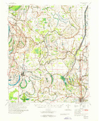 1970 Marks1970 Print · USGSThe Mississippi Delta in the early 1970s reveals a landscape of tight-knit agricultural communities and winding waterways. Genealogists and historians can trace family roots through numerous sites like the Lula-Rich Academy, Posey Mound Cem, and Dickerson Chapel.
 - 1975 Map of Hollywood, 1976 Print
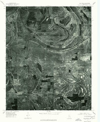 1975 Hollywood1976 Print · USGSThe Mississippi Delta landscape near Tunica is revealed through mid-seventies aerial imagery, documenting a world of precise field patterns and oxbow waterways. Trace the winding paths of Jack Lake Bayou and Whiteoak Bayou through the rural community of Hollywood.
 - 1975 Map of Horseshoe Lake NW, 1976 Print
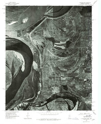
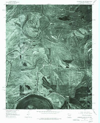 1975 Horseshoe Lake NW1976 Print · USGSThe Arkansas Delta near the Mississippi border comes into sharp focus in the mid-1970s, revealing a landscape of oxbow lakes and precision farming. Genealogists and local historians can trace the street layouts of Hughes and locate the rural settlement of Penjur near Council Lake.
 - 1975 Map of Walnut Lake, 1976 Print
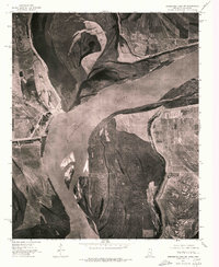
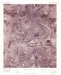 1975 Walnut Lake1976 Print · USGSThe Mississippi Delta landscape near Tunica appears in sharp photographic detail during the mid-1970s. Researchers can trace the winding Coldwater River and the rural settlements of Dubbs and Pink amidst a maze of drainage and fields.
 - 1975 Map of Clayton NW, 1976 Print
 1975 Clayton NW1976 Print · USGSThe Mississippi Delta landscape comes into focus in the mid-1970s, revealing the intricate patterns of agriculture and river movement. Researchers can trace the layout of small communities like Austin and Evansville or explore the banks of Beaverdam Lake.
 - 1975 Map of Horseshoe Lake SE, 1976 Print
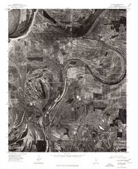
 1975 Horseshoe Lake SE1976 Print · USGSThe Tunica County delta landscape is captured in sharp aerial detail during the mid-seventies, showing the region's agricultural heartland. Genealogists and researchers can trace property layouts and old settlements like Robinsonville, Bowdre, and Penton.2 unique versions available
 - 1975 Map of Horseshoe Lake SW, 1976 Print
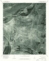
 1975 Horseshoe Lake SW1976 Print · USGSThe winding Mississippi River forms the state line in the mid-1970s, revealing a landscape of active river dynamics and floodplain farming. Genealogists and researchers can locate riverfront settlements like Council, Happy, and Commerce.
 - 1975 Map of Dundee, 1976 Print
 1975 Dundee1976 Print · USGSTunica County's alluvial landscape is revealed through mid-seventies aerial imagery, showing the intersection of industrial farming and ancient river meanders. Researchers can trace the layout of small Delta communities like Dundee and Maud alongside the sweeping curves of Beaverdam Lake.
End of results
Showing maps 1-8 of 8
Top cities of Tunica County
Frequently asked questions
- What are the different types of historical maps available for Tunica County?
- What is the oldest map of Tunica County?
- Where can I purchase historical maps of Tunica County for my home or office?
- Where can I download high-res historical maps of Tunica County?
- Are there historical topographic maps available for Tunica County?
- Is there historical aerial imagery available for Tunica County?
- Where are historical maps of Tunica County sourced from?