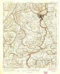
1935 Map of Clarksdale
USGS Topo · Published 1935About this map
The Mississippi River and its dense network of meandering waterways dominate this mid-1930s landscape, illustrating the complex hydrology of the Delta. The Yazoo and Mississippi Valley Railroad serves as the primary spine for development, linking agricultural hubs like Clarksdale, Lyon, and Duncan. Away from the main rail lines, the map reveals a rural landscape deeply organized around local centers of faith and education, including several Rosenwald Schools and numerous country churches such as St James Ch and Morning Star Ch.
Find a feature on this map
121 named features on this map. Tap any name to fly to it.
Don’t see what you’re looking for? This feature index may not catch every label — zoom into the map to look around manually.
Map Details
Editions of this 1935 Clarksdale Map
2 editions found
Other maps of this area

1908 · Coahoma
USGS Topo · 1:24,000

1908 · Jonestown
USGS Topo · 1:24,000

1910 · Coahoma
USGS Topo · 1:31,680

1910 · Jonestown
USGS Topo · 1:31,680

1930 · Mellwood
USGS Topo · 1:62,500

1931 · Sumner
USGS Topo · 1:48,000

1931 · Drew
USGS Topo · 1:48,000

1932 · Tutwiler
USGS Topo · 1:48,000

1932 · Marks
USGS Topo · 1:48,000

1935 · Clarksdale
USGS Topo · 1:62,500