1960s Maps of Carroll County, Mississippi
Explore 9 historic maps of Carroll County from the 1960s. These maps offer a rare glimpse into what life looked like during the 1960s — showing old roads, neighborhoods, homes, and landmarks that have changed or disappeared over time.
Whether you're researching your family's past, planning a metal detecting trip, or studying how Carroll County's landscape evolved across the 1960s, these high-resolution maps are a powerful tool for exploring the history of this region.
- Focus on a specific era: All maps on this page are from the 1960s, giving you a focused view of this time period.
- See what’s changed: Compare century-old streets, trails, and buildings to today's modern landscape using overlays and satellite layers.
- Research with precision: Use these maps for genealogy, historical research, land use analysis, or educational projects.
- View, download, or print: Maps are fully viewable online in high resolution, and can be downloaded or printed for your own records.
Start exploring Carroll County's history through authentic maps from the 1960s. This is your window into the past.
Carroll County, MS maps
(9)- 1963 Map of West Point
 1963 West Point1963 Print · USGSEastern Mississippi and western Alabama are captured in the early sixties as industrial centers and rail lines connected the Black Prairie to the hills. Genealogists and historians can trace family-named watercourses and the early footprints of Starkville, Columbus, and the Noxubee National Wildlife Refuge.2 unique versions available
 - 1964 Map of West, 1965 Print
 1964 West1965 Print · USGSCentral Mississippi hill country and river bottomlands come alive in the 1960s. Genealogists can trace family names through landmarks like Whellin Cem, Brister Cem, and rural congregations at Liberty Hill Ch.2 unique versions available
 - 1964 Map of Bowling Green, 1965 Print
 1964 Bowling Green1965 Print · USGSHolmes County in the mid-1960s reveals a landscape of dispersed rural settlements and historic land divisions. Genealogists and researchers can trace the Old Indian Treaty Boundary and locate family landmarks like Bethesda Chapel, Magee Cem, and the community at Bowling Green.2 unique versions available
 - 1964 Map of Hesterville, 1965 Print
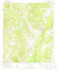
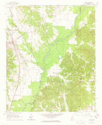
 1964 Hesterville1965 Print · USGSAttala and Carroll counties appear here in the early sixties as a network of creek-bottom farms and rural railroad stops. Genealogists can locate family landmarks like Carmack Sch, Possumneck, and numerous burial sites including Mayo Cem and Guess Cem.
 - 1966 Map of Winona, 1967 Print
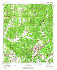
 1966 Winona1967 Print · USGSMid-century Winona thrives at the junction of the Illinois Central and Columbus and Greenville railroads. Researchers can trace family sites at Oakwood Cem or locate rural landmarks like Campbell Hill Ch and Milligan Springs Lake.2 unique versions available
 - 1966 Map of Kosciusko, 1967 Print
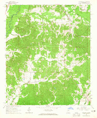
 1966 Kosciusko1967 Print · USGSCentral Mississippi in the mid-sixties centers on Kosciusko and its surrounding rural communities. Genealogists can trace family names through dozens of landmarks like Carmack Sch, Hesterville, and the Bethlehem Cem.
 - 1966 Map of Durant, 1967 Print
 1966 Durant1967 Print · USGSMid-century Holmes County is captured here during a time of steady rail commerce and established rural settlements. Family historians can locate dozens of church-and-cemetery sites such as Bethesda Chapel Cem, Owens Wells, and the Old Indian Treaty Boundary.
 - 1966 Map of Vaiden, 1967 Print
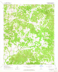
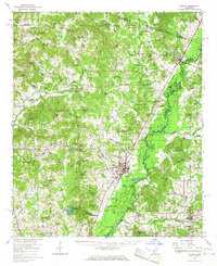
 1966 Vaiden1967 Print · USGSThe town of Vaiden and its surrounding Carroll County hill country are captured here in the mid-1960s, centered on the Big Black River. Genealogists and historians can trace the exact locations of Vaiden Hill Ch, Tuckersville Cem, and the old Illinois Central rail line.2 unique versions available
 - 1968 Map of Winona
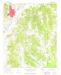
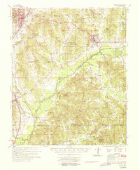 1968 Winona1968 Print · USGSMontgomery County in the late sixties shows a landscape of tight-knit rural communities connected by the Illinois Central railroad and the Big Black River. Genealogists and local historians can trace family roots at Wilmont Cem, Bethlehem Ch, and the old settlement of Poplar Creek.
End of results
Showing maps 1-9 of 9
Top cities of Carroll County
Frequently asked questions
- What are the different types of historical maps available for Carroll County?
- What is the oldest map of Carroll County?
- Where can I purchase historical maps of Carroll County for my home or office?
- Where can I download high-res historical maps of Carroll County?
- Are there historical topographic maps available for Carroll County?
- Is there historical aerial imagery available for Carroll County?
- Where are historical maps of Carroll County sourced from?