1980s Maps of Chickasaw County, Mississippi
Explore 10 historic maps of Chickasaw County from the 1980s. These maps offer a rare glimpse into what life looked like during the 1980s — showing old roads, neighborhoods, homes, and landmarks that have changed or disappeared over time.
Whether you're researching your family's past, planning a metal detecting trip, or studying how Chickasaw County's landscape evolved across the 1980s, these high-resolution maps are a powerful tool for exploring the history of this region.
- Focus on a specific era: All maps on this page are from the 1980s, giving you a focused view of this time period.
- See what’s changed: Compare century-old streets, trails, and buildings to today's modern landscape using overlays and satellite layers.
- Research with precision: Use these maps for genealogy, historical research, land use analysis, or educational projects.
- View, download, or print: Maps are fully viewable online in high resolution, and can be downloaded or printed for your own records.
Start exploring Chickasaw County's history through authentic maps from the 1980s. This is your window into the past.
Chickasaw County, MS maps
(10)- 1982 Map of West Point, 1983 Print
 1982 West Point1983 Print · USGSEastern Mississippi and western Alabama are captured in the early eighties as the river-and-rail economy evolved. Trace family roots and old township lines near West Point, Columbus Air Force Base, and the historic Natchez Trace Parkway.
 - 1984 Map of West Point
 1984 West Point1984 Print · USGSNorth-Central Mississippi in the mid-eighties shows a landscape defined by massive water management projects and dense timberlands. Researchers can trace the legacy of rural settlements like Geeslin Corner or the rail corridors of the Illinois Central Gulf RR near Grenada Lake.3 unique versions available
 - 1984 Map of Tupelo
 1984 Tupelo1984 Print · USGSNorth Mississippi in the 1980s is defined by its massive river basin reservoirs and the growing regional hubs of Tupelo and Oxford. Researchers can trace the legacy of the Pontotoc Ridge, find the University of Mississippi, and map early Interstate corridors near Sardis Lake.3 unique versions available
 - 1984 Map of Tupelo, 1985 Print
 1984 Tupelo1985 Print · USGSNortheast Mississippi and the Alabama borderlands are shown in the mid-1980s as timber and river networks shaped the region. Trace local history through the Illinois Central Gulf rail line and sites like the Old Natchez Trace Parkway.
 - 1984 Map of Oxford, 1985 Print
 1984 Oxford1985 Print · USGSOxford and its surrounding hill country are captured in the mid-eighties as university life and rural industry intersected. Genealogists and historians can trace rail lines like the ST LOUIS-SAN FRANCISCO RY and locate old rural centers such as College Hill Sta and Lafayette Springs.
 - 1984 Map of Grenada, 1990 Print
 1984 Grenada1990 Print · USGSNorth Central Mississippi’s river valleys and conservation lands are captured here in the mid-1980s. Researchers can trace the sprawling Camp Mc Cain, the Illinois Central Gulf rail line, and the historic Treaty Boundary.
 - 1987 Map of Houston East
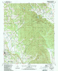 1987 Houston East1987 Print · USGSChickasaw County in the late eighties shows a landscape defined by the Tombigbee National Forest and the growing town of Houston. Researchers can trace old family lines through Ross Hill Cem and Gibbs Cem, or locate landmarks like Bynum Mounds.
 - 1987 Map of Sparta
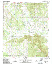 1987 Sparta1987 Print · USGSThe rural borderlands of Chickasaw and Clay Counties are shown in the late 1980s as agricultural life continues alongside the Natchez Trace Parkway. Genealogists can locate family landmarks like Hughes Cem, Oak Grove Cem, and New Zion Ch.
 - 1987 Map of Buena Vista
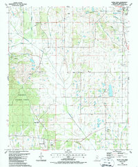 1987 Buena Vista1987 Print · USGSThe rural crossroads of Buena Vista and the outskirts of Okolona appear here in the late twentieth century, showing a landscape of small churches and winding creek bottoms. Genealogists can trace family roots through the many local burial grounds like Pulliam Cem and Jolly Ch Cem or locate the Boone Ch.
 - 1987 Map of Trebloc
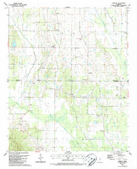 1987 Trebloc1987 Print · USGSChickasaw and Clay County lands are shown in the late 1980s, documenting a landscape of rural hamlets and creek-side cemeteries. Genealogists can locate Trebloc, McCondy, and family landmarks like Thornton Cem or Macedonia Ch.
End of results
Showing maps 1-10 of 10
Top cities of Chickasaw County
Frequently asked questions
- What are the different types of historical maps available for Chickasaw County?
- What is the oldest map of Chickasaw County?
- Where can I purchase historical maps of Chickasaw County for my home or office?
- Where can I download high-res historical maps of Chickasaw County?
- Are there historical topographic maps available for Chickasaw County?
- Is there historical aerial imagery available for Chickasaw County?
- Where are historical maps of Chickasaw County sourced from?