1960s Maps of Covington County, Mississippi
Explore 3 historic maps of Covington County from the 1960s. These maps offer a rare glimpse into what life looked like during the 1960s — showing old roads, neighborhoods, homes, and landmarks that have changed or disappeared over time.
Whether you're researching your family's past, planning a metal detecting trip, or studying how Covington County's landscape evolved across the 1960s, these high-resolution maps are a powerful tool for exploring the history of this region.
- Focus on a specific era: All maps on this page are from the 1960s, giving you a focused view of this time period.
- See what’s changed: Compare century-old streets, trails, and buildings to today's modern landscape using overlays and satellite layers.
- Research with precision: Use these maps for genealogy, historical research, land use analysis, or educational projects.
- View, download, or print: Maps are fully viewable online in high resolution, and can be downloaded or printed for your own records.
Start exploring Covington County's history through authentic maps from the 1960s. This is your window into the past.
Covington County, MS maps
(3)- 1964 Map of Seminary, 1965 Print
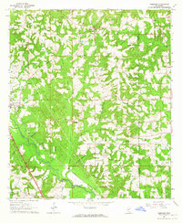 1964 Seminary1965 Print · USGSCovington and Jones Counties are mapped here in the mid-1960s as the regional economy revolved around the rail lines and local gravel pits. Genealogists can trace family landmarks like Speed Cem, Moore Cem, and the rural Union Seminary Ch.3 unique versions available
 - 1965 Map of Hot Coffee, 1966 Print
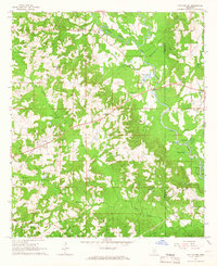 1965 Hot Coffee1966 Print · USGSCovington County in the mid-sixties is a landscape of creek-fed bottomlands and rural crossroads. Genealogists can trace family landmarks like Hot Coffee, Hopewell Sch, and the Oak Grove Cem along the winding Leaf River.2 unique versions available
 - 1965 Map of Sanford, 1966 Print
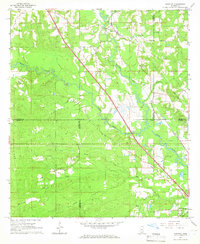 1965 Sanford1966 Print · USGSIn the mid-sixties, the confluence of Bowie Creek and Okatoma Creek anchored a rural landscape of dispersed settlements and rail-side hamlets. Genealogists can trace family landmarks like Byrd Cem and Lott Cem near the Illinois Central line.3 unique versions available
End of results
Showing maps 1-3 of 3
Top cities of Covington County
Frequently asked questions
- What are the different types of historical maps available for Covington County?
- What is the oldest map of Covington County?
- Where can I purchase historical maps of Covington County for my home or office?
- Where can I download high-res historical maps of Covington County?
- Are there historical topographic maps available for Covington County?
- Is there historical aerial imagery available for Covington County?
- Where are historical maps of Covington County sourced from?