1980s Maps of Roxie, Mississippi
Explore 4 historic maps of Roxie from the 1980s. These maps offer a rare glimpse into what life looked like during the 1980s — showing old roads, neighborhoods, homes, and landmarks that have changed or disappeared over time.
Whether you're researching your family's past, planning a metal detecting trip, or studying how Roxie's landscape evolved across the 1980s, these high-resolution maps are a powerful tool for exploring the history of this region.
- Focus on a specific era: All maps on this page are from the 1980s, giving you a focused view of this time period.
- See what’s changed: Compare century-old streets, trails, and buildings to today's modern landscape using overlays and satellite layers.
- Research with precision: Use these maps for genealogy, historical research, land use analysis, or educational projects.
- View, download, or print: Maps are fully viewable online in high resolution, and can be downloaded or printed for your own records.
Start exploring Roxie's history through authentic maps from the 1980s. This is your window into the past.
Roxie, MS maps
(4)- 1984 Map of Natchez
 1984 Natchez1984 Print · USGSThe Mississippi-Louisiana borderlands in the mid-eighties show a landscape defined by the winding Mississippi River and its rail networks. Trace family history at the Natchez National Cemetery or explore the river towns of Vidalia and Ferriday.
 - 1984 Map of Woodville
 1984 Woodville1984 Print · USGSThe Mississippi-Louisiana borderlands in the mid-eighties show a landscape defined by the shifting MISSISSIPPI RIVER and sprawling timberlands. Researchers can trace the ILLINOIS CENTRAL GULF railroad through Gloster or locate historic river points like Fort Adams and Point Breeze.
 - 1988 Map of Knoxville
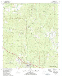
 1988 Knoxville1988 Print · USGSSouthwestern Mississippi's timberlands and evolving energy fields are documented here in the late eighties. Researchers can trace family names and local landmarks at White Apple, McMillan Cem, and the Dry Creek Oil Field.
 - 1988 Map of Roxie
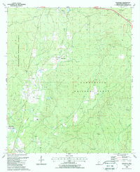
 1988 Roxie1988 Print · USGSFranklin and Jefferson counties are shown here in the late eighties as timber and natural resources shaped the landscape. Researchers can trace family history through numerous rural burial sites like Old Rose Hill Cem and Armstrong Cem or follow the Old Railroad Grade near Hamburg.
End of results
Showing maps 1-4 of 4
Top cities near Roxie
Frequently asked questions
- What are the different types of historical maps available for Roxie?
- What is the oldest map of Roxie?
- Where can I purchase historical maps of Roxie for my home or office?
- Where can I download high-res historical maps of Roxie?
- Are there historical topographic maps available for Roxie?
- Is there historical aerial imagery available for Roxie?
- Where are historical maps of Roxie sourced from?