1990s Maps of Pass Christian, Mississippi
Explore 2 historic maps of Pass Christian from the 1990s. These maps offer a rare glimpse into what life looked like during the 1990s — showing old roads, neighborhoods, homes, and landmarks that have changed or disappeared over time.
Whether you're researching your family's past, planning a metal detecting trip, or studying how Pass Christian's landscape evolved across the 1990s, these high-resolution maps are a powerful tool for exploring the history of this region.
- Focus on a specific era: All maps on this page are from the 1990s, giving you a focused view of this time period.
- See what’s changed: Compare century-old streets, trails, and buildings to today's modern landscape using overlays and satellite layers.
- Research with precision: Use these maps for genealogy, historical research, land use analysis, or educational projects.
- View, download, or print: Maps are fully viewable online in high resolution, and can be downloaded or printed for your own records.
Start exploring Pass Christian's history through authentic maps from the 1990s. This is your window into the past.
Pass Christian, MS maps
(2)- 1993 Map of Bay St. Louis, 1995 Print
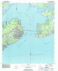 1993 Bay St. Louis1995 Print · USGSThe Mississippi Gulf Coast is captured here in the early nineties, showing the developed waterfronts of Bay St Louis and Pass Christian. Genealogists can trace local landmarks like St Stanislaus College, Trinity Ch, and the Garden Of Memory Cemetery.
 - 1994 Map of Pass Christian, 1995 Print
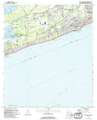 1994 Pass Christian1995 Print · USGSThe Mississippi coast in the early nineties shows the dense growth of Pass Christian and Long Beach. Genealogists and historians can trace institutional landmarks like the U S Naval Reservation and Courtenay Cem.
End of results
Showing maps 1-2 of 2
Top cities near Pass Christian
- Gulfport historical maps
- Biloxi historical maps
- Long Beach historical maps
- Diamondhead historical maps
- Bay Saint Louis historical maps
- Waveland historical maps
Top neighborhoods of Pass Christian
Frequently asked questions
- What are the different types of historical maps available for Pass Christian?
- What is the oldest map of Pass Christian?
- Where can I purchase historical maps of Pass Christian for my home or office?
- Where can I download high-res historical maps of Pass Christian?
- Are there historical topographic maps available for Pass Christian?
- Is there historical aerial imagery available for Pass Christian?
- Where are historical maps of Pass Christian sourced from?