1980s Maps of Byram, Mississippi
Explore 3 historic maps of Byram from the 1980s. These maps offer a rare glimpse into what life looked like during the 1980s — showing old roads, neighborhoods, homes, and landmarks that have changed or disappeared over time.
Whether you're researching your family's past, planning a metal detecting trip, or studying how Byram's landscape evolved across the 1980s, these high-resolution maps are a powerful tool for exploring the history of this region.
- Focus on a specific era: All maps on this page are from the 1980s, giving you a focused view of this time period.
- See what’s changed: Compare century-old streets, trails, and buildings to today's modern landscape using overlays and satellite layers.
- Research with precision: Use these maps for genealogy, historical research, land use analysis, or educational projects.
- View, download, or print: Maps are fully viewable online in high resolution, and can be downloaded or printed for your own records.
Start exploring Byram's history through authentic maps from the 1980s. This is your window into the past.
Byram, MS maps
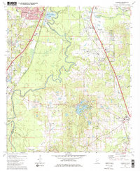
(3)- 1980 Map of New Byram
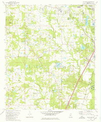 1980 New Byram1980 Print · USGSHinds County during the late 1970s and early 1980s reveals a landscape where the rural South met suburban growth south of Jackson. Researchers can trace family history through sites like Spring Ridge Cem, Wynndale Ch, and the settlement of New Byram.2 unique versions available
 - 1980 Map of Florence
 1980 Florence1980 Print · USGSRankin and Hinds counties are shown here as the capital's southern outskirts grew in the late seventies. Genealogists and historians can trace family locations through Sykes Sch & Ch, McGowen Cem, and the historic banks of the Pearl River.2 unique versions available
 - 1984 Map of Jackson
 1984 Jackson1984 Print · USGSCentral Mississippi in the mid-eighties shows a landscape defined by the growing suburbs of Jackson and the riverfront legacy of Vicksburg. Researchers can trace the Natchez Trace Parkway or locate local landmarks like Utica College and Mississippi State Hospital.
End of results
Showing maps 1-3 of 3
Top cities near Byram
- Jackson historical maps
- Clinton historical maps
- Pearl historical maps
- Brandon historical maps
- Ridgeland historical maps
- Flowood historical maps
See more
Top neighborhoods of Byram
Frequently asked questions
- What are the different types of historical maps available for Byram?
- What is the oldest map of Byram?
- Where can I purchase historical maps of Byram for my home or office?
- Where can I download high-res historical maps of Byram?
- Are there historical topographic maps available for Byram?
- Is there historical aerial imagery available for Byram?
- Where are historical maps of Byram sourced from?