1970s Maps of Raymond, Mississippi
Explore 2 historic maps of Raymond from the 1970s. These maps offer a rare glimpse into what life looked like during the 1970s — showing old roads, neighborhoods, homes, and landmarks that have changed or disappeared over time.
Whether you're researching your family's past, planning a metal detecting trip, or studying how Raymond's landscape evolved across the 1970s, these high-resolution maps are a powerful tool for exploring the history of this region.
- Focus on a specific era: All maps on this page are from the 1970s, giving you a focused view of this time period.
- See what’s changed: Compare century-old streets, trails, and buildings to today's modern landscape using overlays and satellite layers.
- Research with precision: Use these maps for genealogy, historical research, land use analysis, or educational projects.
- View, download, or print: Maps are fully viewable online in high resolution, and can be downloaded or printed for your own records.
Start exploring Raymond's history through authentic maps from the 1970s. This is your window into the past.
Raymond, MS maps
(2)- 1971 Map of Terry NW, 1973 Print
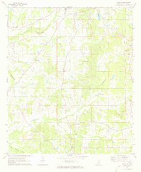 1971 Terry NW1973 Print · USGSRural Hinds County in the early seventies remained a landscape of scattered crossroads and small churches. Researchers can trace family sites at Salmon Cem, explore the community around Dry Grove, or locate the County Penal Farm.
 - 1971 Map of Raymond, 1973 Print
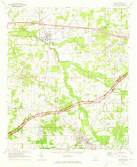 1971 Raymond1973 Print · USGSHinds County is captured here in the early seventies as the historic Natchez Trace Parkway and Illinois Central rail lines shaped the local economy. Genealogists and researchers can trace family landmarks like Zion Chapel Cem, Hinds Jr College, and the old Carver Sch.
End of results
Showing maps 1-2 of 2
Top cities near Raymond
- Jackson historical maps
- Clinton historical maps
- Madison historical maps
- Ridgeland historical maps
- Byram historical maps
- Richland historical maps
See more
Frequently asked questions
- What are the different types of historical maps available for Raymond?
- What is the oldest map of Raymond?
- Where can I purchase historical maps of Raymond for my home or office?
- Where can I download high-res historical maps of Raymond?
- Are there historical topographic maps available for Raymond?
- Is there historical aerial imagery available for Raymond?
- Where are historical maps of Raymond sourced from?