1970s Maps of Tallula, Mississippi
Explore 2 historic maps of Tallula from the 1970s. These maps offer a rare glimpse into what life looked like during the 1970s — showing old roads, neighborhoods, homes, and landmarks that have changed or disappeared over time.
Whether you're researching your family's past, planning a metal detecting trip, or studying how Tallula's landscape evolved across the 1970s, these high-resolution maps are a powerful tool for exploring the history of this region.
- Focus on a specific era: All maps on this page are from the 1970s, giving you a focused view of this time period.
- See what’s changed: Compare century-old streets, trails, and buildings to today's modern landscape using overlays and satellite layers.
- Research with precision: Use these maps for genealogy, historical research, land use analysis, or educational projects.
- View, download, or print: Maps are fully viewable online in high resolution, and can be downloaded or printed for your own records.
Start exploring Tallula's history through authentic maps from the 1970s. This is your window into the past.
Tallula, MS maps
(2)- 1970 Map of Whiting Bayou, 1972 Print
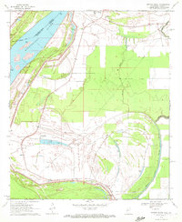 1970 Whiting Bayou1972 Print · USGSThe Mississippi Delta bottomlands come alive in this early 1970s survey of Issaquena County. Researchers can trace the levee-side community of Tallula, the path of an Old Railroad Grade, and several historic black churches including Mt Sinai Ch and Christian Home Ch.
 - 1972 Map of Lake Providence
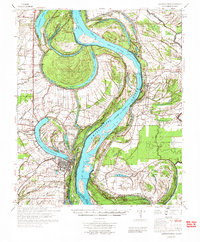 1972 Lake Providence1972 Print · USGSThe Mississippi River delta in the early 1970s reveals a landscape of complex oxbows and river engineering between Louisiana and Mississippi. Genealogists can locate family landmarks like Old St Paul Cem, Briarfield Academy, and the Missouri Pacific rail line.
End of results
Showing maps 1-2 of 2
Top cities near Tallula
- Lake Providence historical maps
- Rolling Fork historical maps
- Mayersville historical maps
- Kilbourne historical maps
- Cary historical maps
Frequently asked questions
- What are the different types of historical maps available for Tallula?
- What is the oldest map of Tallula?
- Where can I purchase historical maps of Tallula for my home or office?
- Where can I download high-res historical maps of Tallula?
- Are there historical topographic maps available for Tallula?
- Is there historical aerial imagery available for Tallula?
- Where are historical maps of Tallula sourced from?