1970s Maps of Bassfield, Mississippi
Explore 4 historic maps of Bassfield from the 1970s. These maps offer a rare glimpse into what life looked like during the 1970s — showing old roads, neighborhoods, homes, and landmarks that have changed or disappeared over time.
Whether you're researching your family's past, planning a metal detecting trip, or studying how Bassfield's landscape evolved across the 1970s, these high-resolution maps are a powerful tool for exploring the history of this region.
- Focus on a specific era: All maps on this page are from the 1970s, giving you a focused view of this time period.
- See what’s changed: Compare century-old streets, trails, and buildings to today's modern landscape using overlays and satellite layers.
- Research with precision: Use these maps for genealogy, historical research, land use analysis, or educational projects.
- View, download, or print: Maps are fully viewable online in high resolution, and can be downloaded or printed for your own records.
Start exploring Bassfield's history through authentic maps from the 1970s. This is your window into the past.
Bassfield, MS maps
(4)- 1970 Map of Bunker Hill, 1972 Print
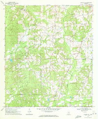 1970 Bunker Hill1972 Print · USGSJefferson Davis and Marion counties appear here during the transition into the 1970s, a period of quiet rural industry and established community life. Genealogists can trace family roots through several local burial grounds and churches, including Old Bassfield Cem, Thompson Chapel Cem, and Shorts Chapel.2 unique versions available
 - 1970 Map of Prentiss East, 1972 Print
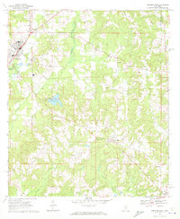 1970 Prentiss East1972 Print · USGSJefferson Davis County comes to life in the early seventies as the rail line connects rural communities and local congregations. Genealogists can locate family landmarks like McPhail Cem and Taylor Cem, or trace the grounds of the Prentiss Institute.
 - 1974 Map of Bassfield, 1978 Print
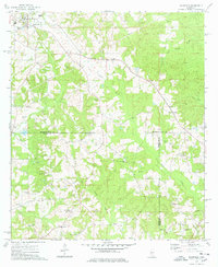 1974 Bassfield1978 Print · USGSJefferson Davis County and the surrounding timberlands appear in the mid-1970s as a landscape of rural churches and family homesteads. Trace the Illinois Central Gulf rail line past Bassfield or locate family sites like McPhail Cem and Raybourn Cem.
 - 1974 Map of Lake Mike Connor, 1978 Print
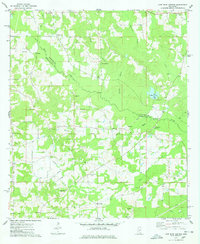 1974 Lake Mike Connor1978 Print · USGSJefferson Davis County and Covington County landscapes come to life in the mid-1970s, showing a region defined by creek branches and country churches. Genealogists can trace family names at Old Chapel Cem, McRaney, and Goodhope Ch Victory Ch.
End of results
Showing maps 1-4 of 4
Top cities near Bassfield
Frequently asked questions
- What are the different types of historical maps available for Bassfield?
- What is the oldest map of Bassfield?
- Where can I purchase historical maps of Bassfield for my home or office?
- Where can I download high-res historical maps of Bassfield?
- Are there historical topographic maps available for Bassfield?
- Is there historical aerial imagery available for Bassfield?
- Where are historical maps of Bassfield sourced from?