
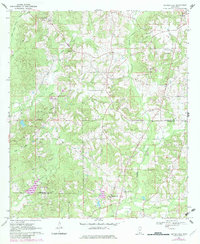
1970 Map of Bunker Hill
USGS Topo · Published 1972About this map
Bassfield and Bunker Hill anchor this rural landscape in the early 1970s, where the headwaters of the West Fork Greens Creek and Holiday Creek define the local topography. The map reveals a community structured around its spiritual and memorial sites, including Friendship Ch, Shorts Chapel, and the Old Bassfield Cem. Across the Jefferson Davis Co Marion Co boundary, the land is marked by numerous Gravel Pits and a prominent Pipeline corridor, signaling the area's mid-century industrial utility. For those tracking family history, the distribution of small burial grounds like Allen Cem and Randle Cem provides essential locations for genealogical research. The presence of the Greens Creek Lookout Tower underscores the significance of forest management and fire observation in this timbered region of southern Mississippi.
Find a feature on this map
25 named features on this map. Tap any name to fly to it.
Don’t see what you’re looking for? This feature index may not catch every label — zoom into the map to look around manually.
Map Details
Editions of this 1970 Bunker Hill Map
2 editions found
Other maps of this area

1953 · Hattiesburg
USGS Topo · 1:250,000

1958 · Hattiesburg
USGS Topo · 1:250,000

1970 · Prentiss West
USGS Topo · 1:24,000

1970 · Morgantown
USGS Topo · 1:24,000

1970 · Oak Vale
USGS Topo · 1:24,000

1970 · Columbia North
USGS Topo · 1:24,000

1970 · Prentiss East
USGS Topo · 1:24,000

1974 · Bassfield
USGS Topo · 1:24,000

1974 · Lake Mike Connor
USGS Topo · 1:24,000

1984 · Hattiesburg
USGS Topo · 1:250,000