1980s Maps of Oxford, Mississippi
Explore 6 historic maps of Oxford from the 1980s. These maps offer a rare glimpse into what life looked like during the 1980s — showing old roads, neighborhoods, homes, and landmarks that have changed or disappeared over time.
Whether you're researching your family's past, planning a metal detecting trip, or studying how Oxford's landscape evolved across the 1980s, these high-resolution maps are a powerful tool for exploring the history of this region.
- Focus on a specific era: All maps on this page are from the 1980s, giving you a focused view of this time period.
- See what’s changed: Compare century-old streets, trails, and buildings to today's modern landscape using overlays and satellite layers.
- Research with precision: Use these maps for genealogy, historical research, land use analysis, or educational projects.
- View, download, or print: Maps are fully viewable online in high resolution, and can be downloaded or printed for your own records.
Start exploring Oxford's history through authentic maps from the 1980s. This is your window into the past.
Oxford, MS maps
(6)- 1980 Map of Oxford South, 1981 Print
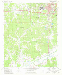 1980 Oxford South1981 Print · USGSOxford and the University of Mississippi expanded southward during the late seventies as the surrounding landscape remained a mix of rural valley and rail corridor. Researchers can locate family landmarks like Craig Cem, New Hope Ch, and the high point at Thacker Mountain.2 unique versions available
 - 1980 Map of Oxford North, 1981 Print
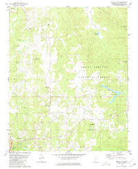
 1980 Oxford North1981 Print · USGSLafayette County in the early eighties shows the northern approach to the university town alongside the waters of the Sardis Lake reservoir. Genealogists can trace family roots through several local landmarks like College Hill, St Peter Cem, and Hammitt Hill Ch.2 unique versions available
 - 1980 Map of Yocona, 1981 Print
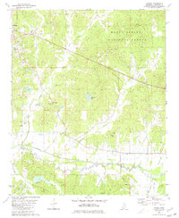 1980 Yocona1981 Print · USGSLafayette County in the early eighties shows a landscape of river bottoms and timberlands south of Oxford. Genealogists can locate family landmarks like Kingdom Cem, Union Grove Ch, and the settlement of Altus.
 - 1980 Map of Bagley Lake, 1981 Print
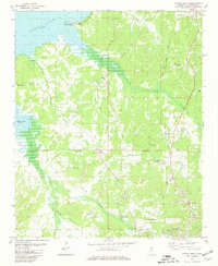
 1980 Bagley Lake1981 Print · USGSLafayette County enters the 1980s as a landscape of timbered national forest and quiet rural crossroads. Genealogists can trace family footprints across numerous historic sites including Cedar Grove Cem, Jefferson Chapel, and the community of McLarty.
 - 1984 Map of Tupelo
 1984 Tupelo1984 Print · USGSNorth Mississippi in the 1980s is defined by its massive river basin reservoirs and the growing regional hubs of Tupelo and Oxford. Researchers can trace the legacy of the Pontotoc Ridge, find the University of Mississippi, and map early Interstate corridors near Sardis Lake.3 unique versions available
 - 1984 Map of Oxford, 1985 Print
 1984 Oxford1985 Print · USGSOxford and its surrounding hill country are captured in the mid-eighties as university life and rural industry intersected. Genealogists and historians can trace rail lines like the ST LOUIS-SAN FRANCISCO RY and locate old rural centers such as College Hill Sta and Lafayette Springs.
End of results
Showing maps 1-6 of 6
Top cities near Oxford
Top neighborhoods of Oxford
Frequently asked questions
- What are the different types of historical maps available for Oxford?
- What is the oldest map of Oxford?
- Where can I purchase historical maps of Oxford for my home or office?
- Where can I download high-res historical maps of Oxford?
- Are there historical topographic maps available for Oxford?
- Is there historical aerial imagery available for Oxford?
- Where are historical maps of Oxford sourced from?