1970s Maps of Lauderdale County, Mississippi
Explore 8 historic maps of Lauderdale County from the 1970s. These maps offer a rare glimpse into what life looked like during the 1970s — showing old roads, neighborhoods, homes, and landmarks that have changed or disappeared over time.
Whether you're researching your family's past, planning a metal detecting trip, or studying how Lauderdale County's landscape evolved across the 1970s, these high-resolution maps are a powerful tool for exploring the history of this region.
- Focus on a specific era: All maps on this page are from the 1970s, giving you a focused view of this time period.
- See what’s changed: Compare century-old streets, trails, and buildings to today's modern landscape using overlays and satellite layers.
- Research with precision: Use these maps for genealogy, historical research, land use analysis, or educational projects.
- View, download, or print: Maps are fully viewable online in high resolution, and can be downloaded or printed for your own records.
Start exploring Lauderdale County's history through authentic maps from the 1970s. This is your window into the past.
Lauderdale County, MS maps
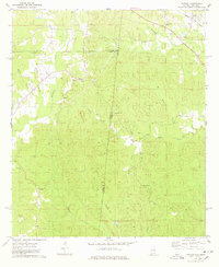
(8)- 1971 Map of Vimville, 1973 Print
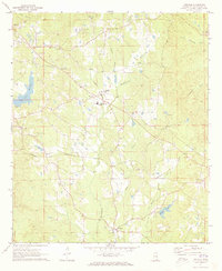 1971 Vimville1973 Print · USGSThe rolling terrain of Lauderdale County comes alive in the early seventies, showing a landscape of rural schools and creek-side settlements. Genealogists can trace family landmarks like Causeyville Ch & Cem, Shamburger Cem, and the community of Vimville.
 - 1971 Map of Meridian South, 1973 Print
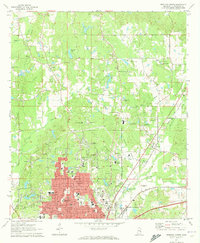
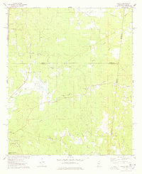
 1971 Meridian South1973 Print · USGSThe growing city of Meridian is captured here in the early seventies as new residential developments spread toward the hills. Researchers can locate numerous family-named landmarks and rural centers like Zero, Savannah Grove, and the historic Rose Hill Cem.2 unique versions available
 - 1971 Map of Meridian North, 1973 Print
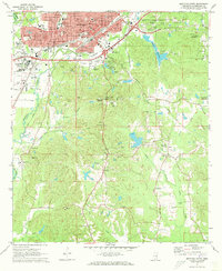
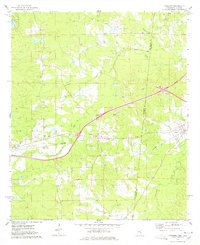
 1971 Meridian North1973 Print · USGSThe northern reaches of Lauderdale County are shown during a period of growth in the early seventies as residential tracts expanded toward Marion. Researchers can trace old family sites and institutions through labels for the Confederate Cem, St Joseph Sch, and the Southern railroad line.2 unique versions available
 - 1971 Map of Toomsuba, 1973 Print
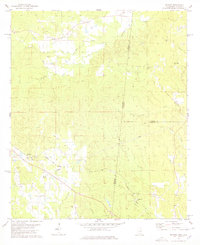
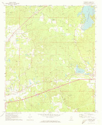 1971 Toomsuba1973 Print · USGSLauderdale County in the early seventies shows a landscape shaped by rail lines and rural community centers. Researchers can trace the development of Toomsuba and Lockhart through landmarks like the Naval Auxiliary Air Station, Akin Airport, and numerous country churches.2 unique versions available
 - 1974 Map of Yantley, 1978 Print
 1974 Yantley1978 Print · USGSChoctaw County at the Alabama-Mississippi border in the mid-1970s reveals a quiet landscape of rural settlements and winding creek bottoms. Researchers can trace family roots at McLendon Cem or explore old community hubs like Cyril and Yantley.
 - 1974 Map of Tamola, 1978 Print
 1974 Tamola1978 Print · USGSIn the 1970s, this Mississippi-Alabama borderland centered on the ILLINOIS CENTRAL GULF railroad and the rural hub of Tamola. Researchers can trace family history at Lauderdale Springs Cem, Mt Hebron Ch, and the Tamola Lookout Tower.2 unique versions available
 - 1974 Map of Kewanee, 1978 Print
 1974 Kewanee1978 Print · USGSThe Mississippi-Alabama borderlands in the 1970s show a landscape of rural communities and evolving infrastructure between Kewanee and Cuba. Genealogists and historians can trace family-named sites like Bethel Cemetery or the local Sweet Pilgrim Ch and Morning Star Ch.
 - 1978 Map of Whynot
 1978 Whynot1978 Print · USGSThis Mississippi-Alabama borderland in the late seventies is a detailed record of rural Lauderdale and Sumter counties. Genealogists can trace family connections through numerous local landmarks like Reids Chapel, McMury Cem, and the settlement of Whynot.
End of results
Showing maps 1-8 of 8
Top cities of Lauderdale County
Frequently asked questions
- What are the different types of historical maps available for Lauderdale County?
- What is the oldest map of Lauderdale County?
- Where can I purchase historical maps of Lauderdale County for my home or office?
- Where can I download high-res historical maps of Lauderdale County?
- Are there historical topographic maps available for Lauderdale County?
- Is there historical aerial imagery available for Lauderdale County?
- Where are historical maps of Lauderdale County sourced from?