1970s Maps of Lee County, Mississippi
Explore 6 historic maps of Lee County from the 1970s. These maps offer a rare glimpse into what life looked like during the 1970s — showing old roads, neighborhoods, homes, and landmarks that have changed or disappeared over time.
Whether you're researching your family's past, planning a metal detecting trip, or studying how Lee County's landscape evolved across the 1970s, these high-resolution maps are a powerful tool for exploring the history of this region.
- Focus on a specific era: All maps on this page are from the 1970s, giving you a focused view of this time period.
- See what’s changed: Compare century-old streets, trails, and buildings to today's modern landscape using overlays and satellite layers.
- Research with precision: Use these maps for genealogy, historical research, land use analysis, or educational projects.
- View, download, or print: Maps are fully viewable online in high resolution, and can be downloaded or printed for your own records.
Start exploring Lee County's history through authentic maps from the 1970s. This is your window into the past.
Lee County, MS maps
(6)- 1973 Map of Guntown, 1975 Print
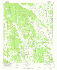
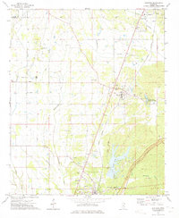 1973 Guntown1975 Print · USGSNortheast Mississippi in the early seventies shows a landscape transitioning between traditional railroad towns and new recreational developments. Genealogists and local historians can trace family-named landmarks like Campbelltown Cem, Euclatubba Ch, and the emerging Natchez Trace Parkway.
 - 1973 Map of Tupelo, 1975 Print
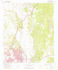 1973 Tupelo1975 Print · USGSTupelo and Lee County are captured here during a period of significant growth and rail-based industry in the early seventies. Genealogists and historians can trace family locations near Fellowship Ch, Beech Springs, or the Chickasaw Village Site.2 unique versions available
 - 1973 Map of Wheeler, 1975 Print
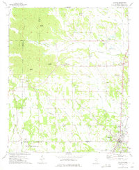
 1973 Wheeler1975 Print · USGSNortheast Mississippi in the early seventies shows a landscape of deep-rooted rural communities and active rail lines. Researchers can trace family history through numerous landmarks like Hodges Chapel Cem, Meadow Creek Ch, and the small settlement at Wheeler.
 - 1973 Map of Baldwyn, 1975 Print
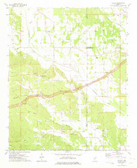
 1973 Baldwyn1975 Print · USGSNorthern Mississippi's hill country and rail corridors are detailed in the early seventies, centered on the historic crossroads at Baldwyn. Researchers can trace the Brice's Cross Roads National Battlefield Site or find old family landmarks like Oak Hill Ch and Sheppard Cem.2 unique versions available
 - 1973 Map of Mooreville, 1975 Print
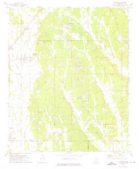
 1973 Mooreville1975 Print · USGSThe rural landscapes of Lee and Itawamba Counties are captured here in the mid-1970s, showcasing a network of small farming settlements and creek-side communities. Family historians can trace long-standing landmarks like Hebron Ch, Gilvo Cem, and the old settlement at Mantachie.
 - 1973 Map of Ratliff, 1975 Print
 1973 Ratliff1975 Print · USGSNortheast Mississippi was a landscape of quiet crossroads and historic creek bottoms in the early seventies. Genealogists can trace family names and local landmarks like Ratliff, the Peterson Cem, and the Natchez Trace Parkway.
End of results
Showing maps 1-6 of 6
Top cities of Lee County
- Tupelo historical maps
- Saltillo historical maps
- Verona historical maps
- Shannon historical maps
- Guntown historical maps
- Plantersville historical maps
Frequently asked questions
- What are the different types of historical maps available for Lee County?
- What is the oldest map of Lee County?
- Where can I purchase historical maps of Lee County for my home or office?
- Where can I download high-res historical maps of Lee County?
- Are there historical topographic maps available for Lee County?
- Is there historical aerial imagery available for Lee County?
- Where are historical maps of Lee County sourced from?