1990s Maps of Saltillo, Mississippi
Explore 2 historic maps of Saltillo from the 1990s. These maps offer a rare glimpse into what life looked like during the 1990s — showing old roads, neighborhoods, homes, and landmarks that have changed or disappeared over time.
Whether you're researching your family's past, planning a metal detecting trip, or studying how Saltillo's landscape evolved across the 1990s, these high-resolution maps are a powerful tool for exploring the history of this region.
- Focus on a specific era: All maps on this page are from the 1990s, giving you a focused view of this time period.
- See what’s changed: Compare century-old streets, trails, and buildings to today's modern landscape using overlays and satellite layers.
- Research with precision: Use these maps for genealogy, historical research, land use analysis, or educational projects.
- View, download, or print: Maps are fully viewable online in high resolution, and can be downloaded or printed for your own records.
Start exploring Saltillo's history through authentic maps from the 1990s. This is your window into the past.
Saltillo, MS maps
(2)- 1992 Map of Guntown, 1995 Print
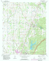 1992 Guntown1995 Print · USGSNortheast Mississippi’s Lee County is shown here in the early nineties during a period of infrastructure growth and rural continuity. Researchers can locate many local landmarks, from the Natchez Trace Parkway to old family plots like Gaston Cem and Campbelltown Cem.
 - 1992 Map of Tupelo, 1995 Print
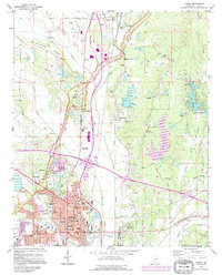 1992 Tupelo1995 Print · USGSTupelo and Saltillo are shown in the early nineties as the region balanced modern growth with its deep cultural roots. Trace family history and local landmarks through sites like the Chickasaw Village Site, Elvis Presley Lake, and the Tupelo National Battlefield.2 unique versions available
End of results
Showing maps 1-2 of 2
Top cities near Saltillo
- Tupelo historical maps
- Verona historical maps
- Baldwyn historical maps
- Guntown historical maps
- Plantersville historical maps
- Mantachie historical maps
See more
Top neighborhoods of Saltillo
Frequently asked questions
- What are the different types of historical maps available for Saltillo?
- What is the oldest map of Saltillo?
- Where can I purchase historical maps of Saltillo for my home or office?
- Where can I download high-res historical maps of Saltillo?
- Are there historical topographic maps available for Saltillo?
- Is there historical aerial imagery available for Saltillo?
- Where are historical maps of Saltillo sourced from?