1980s Maps of Greenwood, Mississippi
Explore 5 historic maps of Greenwood from the 1980s. These maps offer a rare glimpse into what life looked like during the 1980s — showing old roads, neighborhoods, homes, and landmarks that have changed or disappeared over time.
Whether you're researching your family's past, planning a metal detecting trip, or studying how Greenwood's landscape evolved across the 1980s, these high-resolution maps are a powerful tool for exploring the history of this region.
- Focus on a specific era: All maps on this page are from the 1980s, giving you a focused view of this time period.
- See what’s changed: Compare century-old streets, trails, and buildings to today's modern landscape using overlays and satellite layers.
- Research with precision: Use these maps for genealogy, historical research, land use analysis, or educational projects.
- View, download, or print: Maps are fully viewable online in high resolution, and can be downloaded or printed for your own records.
Start exploring Greenwood's history through authentic maps from the 1980s. This is your window into the past.
Greenwood, MS maps
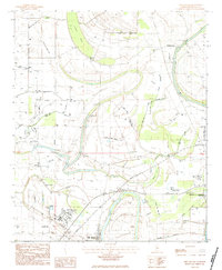
(5)- 1982 Map of Sidon
 1982 Sidon1982 Print · USGSThe Yazoo River delta in the early eighties shows a landscape of oxbow lakes and rail-side settlements. Trace family history at Mt Pisgah Cem or locate old landmarks like the Walker Lake Pumping Plant and Rising Sun Sch.
 - 1982 Map of Greenwood
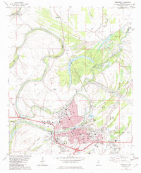 1982 Greenwood1982 Print · USGSGreenwood and its surrounding delta river junctions are captured here in the early eighties. Genealogists and historians can trace family-named sites like Loggins Cem and Little Zion Ch, or locate landmarks like the Florewood River Plantation Museum.
 - 1983 Map of Greenwood
 1983 Greenwood1983 Print · USGSThe Mississippi Delta in the early eighties shows a landscape of rail-connected towns and vast river systems. Genealogists and historians can trace family roots in towns like Mound Bayou, Ruleville, and the grounds of Mississippi Valley State University.
 - 1983 Map of Shellmound, 1984 Print
 1983 Shellmound1984 Print · USGSLeflore County during the early eighties shows a Delta landscape defined by the Tallahatchie River and industrial agriculture. Genealogists can trace rural communities through local landmarks like Mt Zion Ch, St Pauls Cem, and the campus of Mississippi Valley State University.
 - 1984 Map of Indianola, 1985 Print
 1984 Indianola1985 Print · USGSThe Mississippi Delta of the mid-1980s reveals a landscape of fertile bottomlands shaped by the Sunflower River and Yazoo River. Researchers can trace the rail-and-river economy through landmarks like Saints College, the Leflore Cemetery, and the Columbus and Greenville Railway.
End of results
Showing maps 1-5 of 5
Top cities near Greenwood
- Itta Bena historical maps
- Sidon historical maps
- Cruger historical maps
- Schlater historical maps
- Morgan City historical maps
Top neighborhoods of Greenwood
- Baptist Town historical maps
- Hayes Homes historical maps
- North Park historical maps
- Terrace View Apartments historical maps
Frequently asked questions
- What are the different types of historical maps available for Greenwood?
- What is the oldest map of Greenwood?
- Where can I purchase historical maps of Greenwood for my home or office?
- Where can I download high-res historical maps of Greenwood?
- Are there historical topographic maps available for Greenwood?
- Is there historical aerial imagery available for Greenwood?
- Where are historical maps of Greenwood sourced from?