1940s Maps of Potts Camp, Mississippi
Explore 2 historic maps of Potts Camp from the 1940s. These maps offer a rare glimpse into what life looked like during the 1940s — showing old roads, neighborhoods, homes, and landmarks that have changed or disappeared over time.
Whether you're researching your family's past, planning a metal detecting trip, or studying how Potts Camp's landscape evolved across the 1940s, these high-resolution maps are a powerful tool for exploring the history of this region.
- Focus on a specific era: All maps on this page are from the 1940s, giving you a focused view of this time period.
- See what’s changed: Compare century-old streets, trails, and buildings to today's modern landscape using overlays and satellite layers.
- Research with precision: Use these maps for genealogy, historical research, land use analysis, or educational projects.
- View, download, or print: Maps are fully viewable online in high resolution, and can be downloaded or printed for your own records.
Start exploring Potts Camp's history through authentic maps from the 1940s. This is your window into the past.
Potts Camp, MS maps
(2)- 1944 Map of Potts Camp, 1973 Print
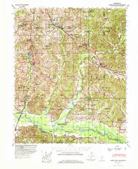 1944 Potts Camp1973 Print · USGSMarshall County's rural landscape is captured here during the mid-1940s, highlighting the area's transition between the national forest and the Tallahatchie valley. Researchers can trace family sites at St Pauls Ch & Cem, the community at Potts Camp, and early engineering like the Tallahatchie Canal.
 - 1945 Map of Potts Camp, 1964 Print
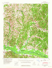 1945 Potts Camp1964 Print · USGSNorth Mississippi's rural timber and farm country comes into focus in the mid-1940s, just as the local landscape was being reshaped by large-scale flood control projects. Genealogists can locate family landmarks such as Bethany Ch & Cem, the Winborn Lookout Tower, and small settlements like Cornersville and Malone.
End of results
Showing maps 1-2 of 2
Top cities near Potts Camp
- Holly Springs historical maps
- Myrtle historical maps
- Ashland historical maps
- Hickory Flat historical maps
- Abbeville historical maps
- Snow Lake Shores historical maps
Frequently asked questions
- What are the different types of historical maps available for Potts Camp?
- What is the oldest map of Potts Camp?
- Where can I purchase historical maps of Potts Camp for my home or office?
- Where can I download high-res historical maps of Potts Camp?
- Are there historical topographic maps available for Potts Camp?
- Is there historical aerial imagery available for Potts Camp?
- Where are historical maps of Potts Camp sourced from?