1980s Maps of Forest, Mississippi
Explore 5 historic maps of Forest from the 1980s. These maps offer a rare glimpse into what life looked like during the 1980s — showing old roads, neighborhoods, homes, and landmarks that have changed or disappeared over time.
Whether you're researching your family's past, planning a metal detecting trip, or studying how Forest's landscape evolved across the 1980s, these high-resolution maps are a powerful tool for exploring the history of this region.
- Focus on a specific era: All maps on this page are from the 1980s, giving you a focused view of this time period.
- See what’s changed: Compare century-old streets, trails, and buildings to today's modern landscape using overlays and satellite layers.
- Research with precision: Use these maps for genealogy, historical research, land use analysis, or educational projects.
- View, download, or print: Maps are fully viewable online in high resolution, and can be downloaded or printed for your own records.
Start exploring Forest's history through authentic maps from the 1980s. This is your window into the past.
Forest, MS maps
(5)- 1982 Map of Harperville, 1983 Print
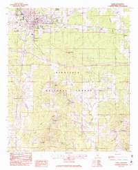
 1982 Harperville1983 Print · USGSScott County in the early eighties reveals a landscape of tight-knit rural communities and forest lands. Genealogists can trace family footprints through sites like Singleton Settlement, Old Union Cem, and numerous country churches including Ephesus Ch.
 - 1982 Map of Forest, 1983 Print
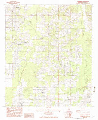
 1982 Forest1983 Print · USGSThe northern reaches of the BIENVILLE NATIONAL FOREST meet the growing town of FOREST in the early 1980s. Genealogists can trace rural roots through numerous churches and cemeteries like Eastern Cem, High Hill Ch, and Gatewood Cem.2 unique versions available
 - 1982 Map of Hillsboro, 1983 Print
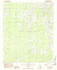 1982 Hillsboro1983 Print · USGSCentral Mississippi's timberlands and rural crossroads are captured here in the early eighties. Genealogists and historians can trace family sites at Old Duncan Cem or follow the Shockaloe Trail through Bienville National Forest.
 - 1982 Map of Pulaski, 1983 Print
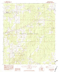 1982 Pulaski1983 Print · USGSCentral Mississippi timberlands and small rail-side settlements define this landscape in the early eighties. Genealogists can trace family names through landmarks like North Morton Cem, Raworth, and Hunter Town near the Strong River.
 - 1984 Map of Forest
 1984 Forest1984 Print · USGSCentral Mississippi in the mid-eighties centers on the timberlands and rail corridors of the Bienville National Forest. Genealogists and historians can trace old settlements like Conehatta and Hillsboro or follow the Illinois Central Gulf line through Morton and Newton.2 unique versions available
End of results
Showing maps 1-5 of 5
Top cities near Forest
Frequently asked questions
- What are the different types of historical maps available for Forest?
- What is the oldest map of Forest?
- Where can I purchase historical maps of Forest for my home or office?
- Where can I download high-res historical maps of Forest?
- Are there historical topographic maps available for Forest?
- Is there historical aerial imagery available for Forest?
- Where are historical maps of Forest sourced from?