1960s Maps of Smith County, Mississippi
Explore 9 historic maps of Smith County from the 1960s. These maps offer a rare glimpse into what life looked like during the 1960s — showing old roads, neighborhoods, homes, and landmarks that have changed or disappeared over time.
Whether you're researching your family's past, planning a metal detecting trip, or studying how Smith County's landscape evolved across the 1960s, these high-resolution maps are a powerful tool for exploring the history of this region.
- Focus on a specific era: All maps on this page are from the 1960s, giving you a focused view of this time period.
- See what’s changed: Compare century-old streets, trails, and buildings to today's modern landscape using overlays and satellite layers.
- Research with precision: Use these maps for genealogy, historical research, land use analysis, or educational projects.
- View, download, or print: Maps are fully viewable online in high resolution, and can be downloaded or printed for your own records.
Start exploring Smith County's history through authentic maps from the 1960s. This is your window into the past.
Smith County, MS maps
(9)- 1965 Map of Meridian
 1965 Meridian1965 Print · USGSEast Mississippi and West Alabama are mapped here in the mid-sixties as the region's modern highway and reservoir systems began to take shape. Researchers can trace rural lineages through local landmarks like Prince Chapel and Tuscahoma Landing, or follow the historic Gulf Mobile & Ohio rail lines.
 - 1968 Map of Clear Springs, 1970 Print
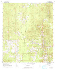
 1968 Clear Springs1970 Print · USGSCentral Mississippi's piney woods come alive in the late sixties, showing where the borders of four counties meet within the Bienville National Forest. Genealogists and historians can trace the rural communities around Clear Springs, Mt Calvary Ch, and the Burnett Cem.
 - 1968 Map of Pineville, 1970 Print
 1968 Pineville1970 Print · USGSThe Pineville area of Mississippi's Bienville National Forest is captured here in the late sixties as a landscape of timber and rural community. Researchers can trace the Old Railroad Grade or locate family landmarks like Noblin Cem, Mt Carmel Ch, and Oak Ridge Ch.2 unique versions available
 - 1968 Map of Homewood, 1970 Print
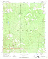
 1968 Homewood1970 Print · USGSIn the pine-heavy borderlands of Scott and Smith counties during the late sixties, rural life centered on small timber and mining outposts. Researchers can trace family history through sites like Burns Sch and Zion Cem or locate industrial Bentonite Pits near Lorena.2 unique versions available
 - 1968 Map of White Oak, 1970 Print
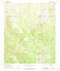
 1968 White Oak1970 Print · USGSSmith and Simpson counties meet along the Strong River in the late sixties as the timber and oil industries shaped the land. Genealogists can locate family landmarks like Miley Cem and Merchant Cem or trace the Old Indian Treaty Boundary.3 unique versions available
 - 1968 Map of Polkville, 1970 Print
 1968 Polkville1970 Print · USGSCentral Mississippi's timber and farm country comes into focus in the late 1960s, centered on the community of Polkville. Researchers can trace early land divisions along the Old Indian Treaty Boundary and locate family landmarks like Haile Cem and Piney Grove Ch.3 unique versions available
 - 1968 Map of Raleigh, 1970 Print
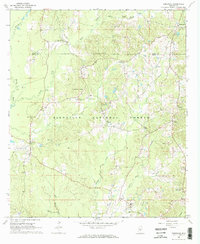
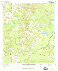
 1968 Raleigh1970 Print · USGSRaleigh and the surrounding Smith County countryside are captured here in the late sixties, just as the regional landscape was being shaped by forestry and oil. Researchers can find numerous family landmarks and rural institutions, from St Paul Ch and Crossroads Ch to the Bentonite Pit.
 - 1968 Map of Louin, 1970 Print
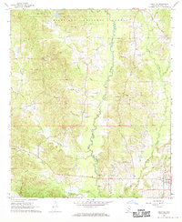
 1968 Louin1970 Print · USGSThe Jasper County interior comes into focus during the late sixties, showcasing the intersection of timberlands and rail-dependent settlements. Researchers can trace family roots through numerous sites like Triumph Ch, Bethany Cem, and the rail stop at Louin.2 unique versions available
 - 1968 Map of Louin SW, 1970 Print
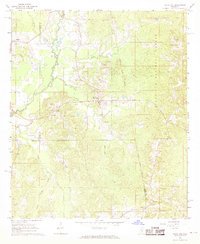
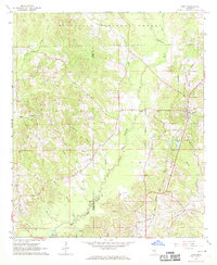
 1968 Louin SW1970 Print · USGSSmith County, Mississippi, is shown here in the late sixties as a landscape of timberland and rural homesteads. Genealogists and historians can locate remote landmarks like Sylvan Grove Cem, Wadell Cave, and the community at Sylvarena.
End of results
Showing maps 1-9 of 9
Top cities of Smith County
- Taylorsville historical maps
- Raleigh historical maps
- Mize historical maps
- Polkville historical maps
- Sylvarena historical maps
Frequently asked questions
- What are the different types of historical maps available for Smith County?
- What is the oldest map of Smith County?
- Where can I purchase historical maps of Smith County for my home or office?
- Where can I download high-res historical maps of Smith County?
- Are there historical topographic maps available for Smith County?
- Is there historical aerial imagery available for Smith County?
- Where are historical maps of Smith County sourced from?