1930s Maps of Evansville, Mississippi
Explore 2 historic maps of Evansville from the 1930s. These maps offer a rare glimpse into what life looked like during the 1930s — showing old roads, neighborhoods, homes, and landmarks that have changed or disappeared over time.
Whether you're researching your family's past, planning a metal detecting trip, or studying how Evansville's landscape evolved across the 1930s, these high-resolution maps are a powerful tool for exploring the history of this region.
- Focus on a specific era: All maps on this page are from the 1930s, giving you a focused view of this time period.
- See what’s changed: Compare century-old streets, trails, and buildings to today's modern landscape using overlays and satellite layers.
- Research with precision: Use these maps for genealogy, historical research, land use analysis, or educational projects.
- View, download, or print: Maps are fully viewable online in high resolution, and can be downloaded or printed for your own records.
Start exploring Evansville's history through authentic maps from the 1930s. This is your window into the past.
Evansville, MS maps
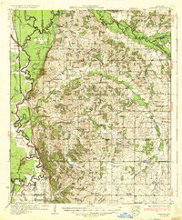
(2)- 1932 Map of Crenshaw, 1964 Print
 1932 Crenshaw1964 Print · USGSNorthwest Mississippi in the early thirties reveals a complex network of Delta bayous and hill-country settlements. Genealogists can trace family roots through dozens of rural landmarks, from Cottonville Store to Brooks Chapel and the Longtown Sch.
 - 1935 Map of Crenshaw
 1935 Crenshaw1935 Print · USGSNorthwest Mississippi in the mid-thirties was a landscape of intricate bayous and thriving rural communities tied to the rail and river. Genealogists can trace family roots through numerous local landmarks like Cottonville Store, New Salem Ch, and Spring Hill Sch.2 unique versions available
End of results
Showing maps 1-2 of 2
Top cities near Evansville
Frequently asked questions
- What are the different types of historical maps available for Evansville?
- What is the oldest map of Evansville?
- Where can I purchase historical maps of Evansville for my home or office?
- Where can I download high-res historical maps of Evansville?
- Are there historical topographic maps available for Evansville?
- Is there historical aerial imagery available for Evansville?
- Where are historical maps of Evansville sourced from?