1990s Maps of New Albany, Mississippi
Explore 2 historic maps of New Albany from the 1990s. These maps offer a rare glimpse into what life looked like during the 1990s — showing old roads, neighborhoods, homes, and landmarks that have changed or disappeared over time.
Whether you're researching your family's past, planning a metal detecting trip, or studying how New Albany's landscape evolved across the 1990s, these high-resolution maps are a powerful tool for exploring the history of this region.
- Focus on a specific era: All maps on this page are from the 1990s, giving you a focused view of this time period.
- See what’s changed: Compare century-old streets, trails, and buildings to today's modern landscape using overlays and satellite layers.
- Research with precision: Use these maps for genealogy, historical research, land use analysis, or educational projects.
- View, download, or print: Maps are fully viewable online in high resolution, and can be downloaded or printed for your own records.
Start exploring New Albany's history through authentic maps from the 1990s. This is your window into the past.
New Albany, MS maps
(2)- 1990 Map of Oxford, 1991 Print
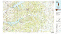 1990 Oxford1991 Print · USGSNorth Mississippi at the start of the nineties centers on the university town of Oxford and the large reservoirs of the Tallahatchie River valley. Researchers can trace the Illinois Central Gulf RR through towns like Water Valley and locate landmarks such as College Hill Sta.
 - 1994 Map of Corinth
 1994 Corinth1994 Print · USGSNortheast Mississippi and the Tennessee borderlands are captured in the mid-1990s as the region's modern industrial and recreational landscape took shape. Genealogists and historians can trace rail-to-river connections through Corinth, the old courthouse at Jacinto, and the route of the Natchez Trace Parkway.
End of results
Showing maps 1-2 of 2
Top cities near New Albany
- Tupelo historical maps
- Pontotoc historical maps
- Ripley historical maps
- Ecru historical maps
- Blue Mountain historical maps
- Thaxton historical maps
See more
Top neighborhoods of New Albany
Frequently asked questions
- What are the different types of historical maps available for New Albany?
- What is the oldest map of New Albany?
- Where can I purchase historical maps of New Albany for my home or office?
- Where can I download high-res historical maps of New Albany?
- Are there historical topographic maps available for New Albany?
- Is there historical aerial imagery available for New Albany?
- Where are historical maps of New Albany sourced from?