1970s Maps of Greenville, Mississippi
Explore 4 historic maps of Greenville from the 1970s. These maps offer a rare glimpse into what life looked like during the 1970s — showing old roads, neighborhoods, homes, and landmarks that have changed or disappeared over time.
Whether you're researching your family's past, planning a metal detecting trip, or studying how Greenville's landscape evolved across the 1970s, these high-resolution maps are a powerful tool for exploring the history of this region.
- Focus on a specific era: All maps on this page are from the 1970s, giving you a focused view of this time period.
- See what’s changed: Compare century-old streets, trails, and buildings to today's modern landscape using overlays and satellite layers.
- Research with precision: Use these maps for genealogy, historical research, land use analysis, or educational projects.
- View, download, or print: Maps are fully viewable online in high resolution, and can be downloaded or printed for your own records.
Start exploring Greenville's history through authentic maps from the 1970s. This is your window into the past.
Greenville, MS maps
(4)- 1970 Map of Greenville, 1972 Print
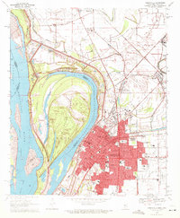 1970 Greenville1972 Print · USGSGreenville and the Mississippi River frontline are captured here in the early seventies, showing a landscape shaped by massive river cutoffs. Genealogists can locate family landmarks like Old Mt Tabor Cem, Macedonia Ch, and Winterville.2 unique versions available
 - 1970 Map of Wayside, 1972 Print
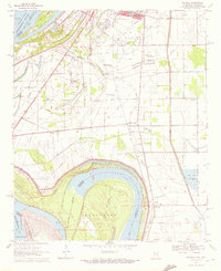 1970 Wayside1972 Print · USGSThe Mississippi Delta riverfront south of Greenville appears here in the early seventies, defined by oxbows and rural church communities. Genealogists and historians can trace family locations near Lakeview Gardens Cem, Wayside, and The Old Evening Star Ch.
 - 1970 Map of Red Leaf, 1972 Print
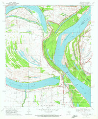 1970 Red Leaf1972 Print · USGSThe Arkansas riverlands near the Mississippi border appear in the early 1970s, defined by the winding waters of Lake Chicot and Stuart Island. Genealogists and historians can locate rural landmarks like Red Leaf Cem, Jerusalem Ch, and the settlement of Vaucluse.2 unique versions available
 - 1972 Map of Greenville
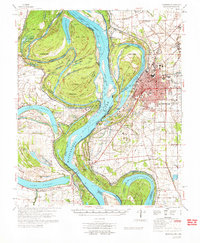 1972 Greenville1972 Print · USGSThe Mississippi Delta's winding riverbanks and fertile lowlands are captured here in the early seventies, detailing the region's complex water management and rural settlements. Genealogists can locate family-named landmarks like The Old Evening Star Ch, Trigg Sch, and the Red Leaf Cem across the Washington County landscape.
End of results
Showing maps 1-4 of 4
Top cities near Greenville
- Leland historical maps
- Hollandale historical maps
- Lake Village historical maps
- Metcalfe historical maps
- Arcola historical maps
- Arkansas City historical maps
Top neighborhoods of Greenville
Frequently asked questions
- What are the different types of historical maps available for Greenville?
- What is the oldest map of Greenville?
- Where can I purchase historical maps of Greenville for my home or office?
- Where can I download high-res historical maps of Greenville?
- Are there historical topographic maps available for Greenville?
- Is there historical aerial imagery available for Greenville?
- Where are historical maps of Greenville sourced from?