1930s Maps of Milton, Missouri
Explore 2 historic maps of Milton from the 1930s. These maps offer a rare glimpse into what life looked like during the 1930s — showing old roads, neighborhoods, homes, and landmarks that have changed or disappeared over time.
Whether you're researching your family's past, planning a metal detecting trip, or studying how Milton's landscape evolved across the 1930s, these high-resolution maps are a powerful tool for exploring the history of this region.
- Focus on a specific era: All maps on this page are from the 1930s, giving you a focused view of this time period.
- See what’s changed: Compare century-old streets, trails, and buildings to today's modern landscape using overlays and satellite layers.
- Research with precision: Use these maps for genealogy, historical research, land use analysis, or educational projects.
- View, download, or print: Maps are fully viewable online in high resolution, and can be downloaded or printed for your own records.
Start exploring Milton's history through authentic maps from the 1930s. This is your window into the past.
Milton, MO maps
(2)- 1936 Map of Fairfax
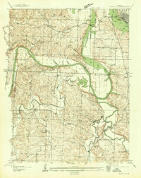 1936 Fairfax1936 Print · USGSBenton and Hickory counties are captured in the mid-1930s just as the Lake of the Ozarks was reshaping the Osage River valley. Trace family roots at Wisdom Cem or locate the old Hogles Creek Sch and the community at Fairfield.
 - 1939 Map of Tarkio
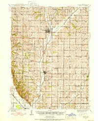 1939 Tarkio1939 Print · USGSNorthwest Missouri's farm country is captured here just before the mid-century, showing a landscape defined by the Tarkio River and a dense grid of rural schoolhouses. Researchers can trace family history through dozens of named landmarks like Tarkio College, Busch Cem, and the Chicago Burlington and Quincy rail line.
End of results
Showing maps 1-2 of 2
Top cities near Milton
- Falls City historical maps
- Tarkio historical maps
- Rock Port historical maps
- Mound City historical maps
- Fairfax historical maps
- Craig historical maps
See more
Frequently asked questions
- What are the different types of historical maps available for Milton?
- What is the oldest map of Milton?
- Where can I purchase historical maps of Milton for my home or office?
- Where can I download high-res historical maps of Milton?
- Are there historical topographic maps available for Milton?
- Is there historical aerial imagery available for Milton?
- Where are historical maps of Milton sourced from?