1970s Maps of Butterfield, Missouri
Explore 2 historic maps of Butterfield from the 1970s. These maps offer a rare glimpse into what life looked like during the 1970s — showing old roads, neighborhoods, homes, and landmarks that have changed or disappeared over time.
Whether you're researching your family's past, planning a metal detecting trip, or studying how Butterfield's landscape evolved across the 1970s, these high-resolution maps are a powerful tool for exploring the history of this region.
- Focus on a specific era: All maps on this page are from the 1970s, giving you a focused view of this time period.
- See what’s changed: Compare century-old streets, trails, and buildings to today's modern landscape using overlays and satellite layers.
- Research with precision: Use these maps for genealogy, historical research, land use analysis, or educational projects.
- View, download, or print: Maps are fully viewable online in high resolution, and can be downloaded or printed for your own records.
Start exploring Butterfield's history through authentic maps from the 1970s. This is your window into the past.
Butterfield, MO maps
(2)- 1972 Map of Purdy, 1973 Print
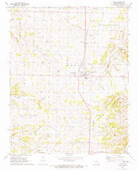 1972 Purdy1973 Print · USGSBarry County was a landscape of rail-connected towns and country parishes in the early seventies, centered on the St Louis - San Francisco line. Genealogists can locate family landmarks like Henderson Cem, Stinett Cem, and the settlement of Corsicana.
 - 1974 Map of Exeter, 1977 Print
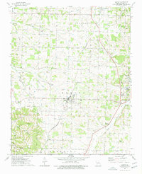 1974 Exeter1977 Print · USGSBarry County in the mid-seventies maintains its rural character as the St Louis-San Francisco railroad continues to link the towns of Butterfield and Exeter. Researchers can trace old family sites at Vineyard Cem or follow the path of the Old Railroad Grade through the hills.
End of results
Showing maps 1-2 of 2
Top cities near Butterfield
- Monett historical maps
- Aurora historical maps
- Cassville historical maps
- Pierce City historical maps
- Purdy historical maps
- Seligman historical maps
See more
Frequently asked questions
- What are the different types of historical maps available for Butterfield?
- What is the oldest map of Butterfield?
- Where can I purchase historical maps of Butterfield for my home or office?
- Where can I download high-res historical maps of Butterfield?
- Are there historical topographic maps available for Butterfield?
- Is there historical aerial imagery available for Butterfield?
- Where are historical maps of Butterfield sourced from?