1900s (20th Century) Maps of Lamar, Missouri
Explore 12 historic maps of Lamar from the 1900s (20th Century). These maps offer a rare glimpse into what life looked like during the 1900s — showing old roads, neighborhoods, homes, and landmarks that have changed or disappeared over time.
Whether you're researching your family's past, planning a metal detecting trip, or studying how Lamar's landscape evolved across the 1900s, these high-resolution maps are a powerful tool for exploring the history of this region.
- Focus on a specific era: All maps on this page are from the 1900s, giving you a focused view of this time period.
- See what’s changed: Compare century-old streets, trails, and buildings to today's modern landscape using overlays and satellite layers.
- Research with precision: Use these maps for genealogy, historical research, land use analysis, or educational projects.
- View, download, or print: Maps are fully viewable online in high resolution, and can be downloaded or printed for your own records.
Start exploring Lamar's history through authentic maps from the 1900s. This is your window into the past.
Lamar, MO maps
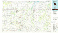
(12)- 1947 Map of Joplin, 1954 Print
 1947 Joplin1954 Print · USGSThe borderlands of Missouri, Kansas, and Oklahoma are shown here during the late 1940s, a period of heavy industrial and military activity. Researchers can trace the extensive Tri-State Mining District, the layout of Camp Crowder, and local landmarks like Mount Hope Cem.
 - 1949 Map of Joplin
 1949 Joplin1949 Print · USGSThe Kansas-Missouri borderlands thrive in the late 1940s, showing a robust network of railroad towns and river valleys. Researchers can trace historic rail lines like the Missouri Pacific RR and locate rural centers such as Chanute, Iola, and Fort Scott.
 - 1954 Map of Joplin, 1967 Print
 1954 Joplin1967 Print · USGSThe tri-state border region of Kansas, Missouri, and Oklahoma is captured here during a peak era of mid-century industrial and agricultural activity. Researchers can trace family history through dozens of rural cemeteries or locate landmarks like the Kansas Army Ammunition Plant and Pittsburg State University.3 unique versions available
 - 1958 Map of Joplin
 1958 Joplin1958 Print · USGSThe tri-state border region of Missouri, Kansas, and Oklahoma is shown during the late fifties, a time of heavy rail traffic and mining activity. Local historians can trace the industrial landscape through the Joplin & Pittsburg Ry or locate family sites like Zion Ch and Bender Mounds.
 - 1959 Map of Joplin
 1959 Joplin1959 Print · USGSThe Tri-State region’s mining and rail-driven economy is on full display in the late fifties. Genealogists can locate Lead and Zinc Mines near Joplin, family markers at Oak Hill Cem, and military history at Camp Clark.
 - 1962 Map of Kenoma, 1963 Print
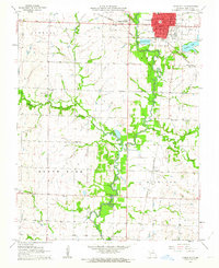
 1962 Kenoma1963 Print · USGSBarton County farming life is captured here in the early sixties, showing a landscape defined by traditional township boundaries and the ST Louis - San Francisco railroad. Genealogists can locate family landmarks like Mt Carmel Ch, Fair View Cem, and numerous rural schoolhouses including Glendale Sch.2 unique versions available
 - 1962 Map of Lamar North, 1963 Print
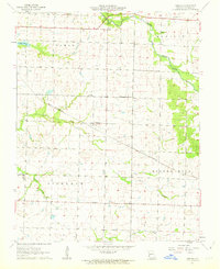
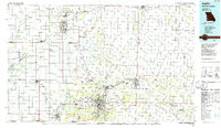
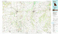
 1962 Lamar North1963 Print · USGSBarton County is shown here in the early 1960s, a landscape shaped by the intersection of the Missouri Pacific and St Louis San Francisco railroads. Researchers can locate rural landmarks like Central Chapel, Bakers Grove Cem, and several country schools.
 - 1962 Map of Lamar South, 1964 Print
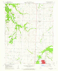
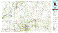
 1962 Lamar South1964 Print · USGSBarton County in the early sixties shows the growth of Lamar City and the rural townships of Richland and North. Genealogists can trace early landmarks like St Marys Cem, Bethel Ch, and forgotten school sites like Ledbetter Sch.
 - 1986 Map of Nevada
 1986 Nevada1986 Print · USGSThe Missouri-Kansas borderlands in the mid-1980s show a landscape of active rail lines and coal mining. Researchers can trace the Old Military Road or locate family plots in the National Cemetery and Deepwood Cemetery.
 - 1986 Map of Joplin
 1986 Joplin1986 Print · USGSThe tri-state border region comes alive in the mid-eighties as an industrial and transit powerhouse where Kansas and Missouri meet. Researchers can trace the heavy rail influence of the Missouri Pacific RR and explore sites like the Mined Land State Wildlife Area.
 - 1991 Map of Joplin
 1991 Joplin1991 Print · USGSThe tri-state mining district and the Ozark foothills meet in the early 1990s as industrial land transitions into conservation areas. Genealogists and historians can trace the growth of Joplin and Baxter Springs or locate rural sites like Mount Hope Cem and Blue Mound.
 - 1991 Map of Nevada
 1991 Nevada1991 Print · USGSThis borderland region in the early nineties captures the transition from Kansas plains to Missouri timber. Researchers can trace family history through Bunn Cemetery, locate the Camp Clark Military Reservation, and explore rail towns like Nevada and Fort Scott.
End of results
Showing maps 1-12 of 12
Top cities near Lamar
- Jasper historical maps
- Golden City historical maps
- Liberal historical maps
- Sheldon historical maps
- Nashville historical maps
- Newport historical maps
See more
Frequently asked questions
- What are the different types of historical maps available for Lamar?
- What is the oldest map of Lamar?
- Where can I purchase historical maps of Lamar for my home or office?
- Where can I download high-res historical maps of Lamar?
- Are there historical topographic maps available for Lamar?
- Is there historical aerial imagery available for Lamar?
- Where are historical maps of Lamar sourced from?