1930s Maps of Arab, Missouri
Explore 2 historic maps of Arab from the 1930s. These maps offer a rare glimpse into what life looked like during the 1930s — showing old roads, neighborhoods, homes, and landmarks that have changed or disappeared over time.
Whether you're researching your family's past, planning a metal detecting trip, or studying how Arab's landscape evolved across the 1930s, these high-resolution maps are a powerful tool for exploring the history of this region.
- Focus on a specific era: All maps on this page are from the 1930s, giving you a focused view of this time period.
- See what’s changed: Compare century-old streets, trails, and buildings to today's modern landscape using overlays and satellite layers.
- Research with precision: Use these maps for genealogy, historical research, land use analysis, or educational projects.
- View, download, or print: Maps are fully viewable online in high resolution, and can be downloaded or printed for your own records.
Start exploring Arab's history through authentic maps from the 1930s. This is your window into the past.
Arab, MO maps
(2)- 1935 Map of Zalma
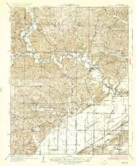 1935 Zalma1935 Print · USGSSoutheast Missouri in the mid-1930s reveals a landscape undergoing transformation through massive drainage projects and the reach of the rail. Trace old schoolhouses like Patterson Sch, vanished landmarks like Sitzke Store, and the path of the St Louis San Francisco railroad.3 unique versions available
 - 1939 Map of Zalma, 1943 Print
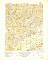 1939 Zalma1943 Print · USGSSoutheast Missouri’s river hills and delta margins are captured here in the late thirties, as the region’s drainage and rail networks were undergoing significant change. Genealogists can trace family names through landmarks like the Buchanan Post Office, Bright Prospect Ch, and Snake Bluff School No 2.2 unique versions available
End of results
Showing maps 1-2 of 2
Top cities near Arab
- Bloomfield historical maps
- Marble Hill historical maps
- Advance historical maps
- Puxico historical maps
- Zalma historical maps
Frequently asked questions
- What are the different types of historical maps available for Arab?
- What is the oldest map of Arab?
- Where can I purchase historical maps of Arab for my home or office?
- Where can I download high-res historical maps of Arab?
- Are there historical topographic maps available for Arab?
- Is there historical aerial imagery available for Arab?
- Where are historical maps of Arab sourced from?