1940s Maps of Poplar Bluff, Missouri
Explore 1 historic maps of Poplar Bluff from the 1940s. These maps offer a rare glimpse into what life looked like during the 1940s — showing old roads, neighborhoods, homes, and landmarks that have changed or disappeared over time.
Whether you're researching your family's past, planning a metal detecting trip, or studying how Poplar Bluff's landscape evolved across the 1940s, these high-resolution maps are a powerful tool for exploring the history of this region.
- Focus on a specific era: All maps on this page are from the 1940s, giving you a focused view of this time period.
- See what’s changed: Compare century-old streets, trails, and buildings to today's modern landscape using overlays and satellite layers.
- Research with precision: Use these maps for genealogy, historical research, land use analysis, or educational projects.
- View, download, or print: Maps are fully viewable online in high resolution, and can be downloaded or printed for your own records.
Start exploring Poplar Bluff's history through authentic maps from the 1940s. This is your window into the past.
Poplar Bluff, MO maps
(1)- 1949 Map of Poplar Bluff, 1964 Print
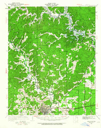 1949 Poplar Bluff1964 Print · USGSThe area surrounding Poplar Bluff is shown during a period of transition as the Ozark hills meet the engineered drainage canals of the lowlands. Researchers can trace the St Louis San Francisco railroad through rural stops like Chaonia and Taskee Sta.
End of results
Showing maps 1-1 of 1
Top cities near Poplar Bluff
- Naylor historical maps
- Neelyville historical maps
- Qulin historical maps
- Fisk historical maps
- Williamsville historical maps
Top neighborhoods of Poplar Bluff
- Ashcroft Addition historical maps
- Loma Linda historical maps
- Cedar Valley historical maps
- Kelly Town historical maps
- Vinegar Hill historical maps
Frequently asked questions
- What are the different types of historical maps available for Poplar Bluff?
- What is the oldest map of Poplar Bluff?
- Where can I purchase historical maps of Poplar Bluff for my home or office?
- Where can I download high-res historical maps of Poplar Bluff?
- Are there historical topographic maps available for Poplar Bluff?
- Is there historical aerial imagery available for Poplar Bluff?
- Where are historical maps of Poplar Bluff sourced from?