1930s Maps of Poplar Bluff, Missouri
Explore 3 historic maps of Poplar Bluff from the 1930s. These maps offer a rare glimpse into what life looked like during the 1930s — showing old roads, neighborhoods, homes, and landmarks that have changed or disappeared over time.
Whether you're researching your family's past, planning a metal detecting trip, or studying how Poplar Bluff's landscape evolved across the 1930s, these high-resolution maps are a powerful tool for exploring the history of this region.
- Focus on a specific era: All maps on this page are from the 1930s, giving you a focused view of this time period.
- See what’s changed: Compare century-old streets, trails, and buildings to today's modern landscape using overlays and satellite layers.
- Research with precision: Use these maps for genealogy, historical research, land use analysis, or educational projects.
- View, download, or print: Maps are fully viewable online in high resolution, and can be downloaded or printed for your own records.
Start exploring Poplar Bluff's history through authentic maps from the 1930s. This is your window into the past.
Poplar Bluff, MO maps
(3)- 1935 Map of Poplar Bluff
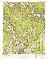 1935 Poplar Bluff1935 Print · USGSSoutheast Missouri’s river-and-rail landscape is captured here in the mid-thirties as the timber and agricultural economy flourished. Trace family homesteads near Taskee Sta, identify old rural schools like Snyder Sch, and follow the original routes of the Missouri Pacific.3 unique versions available
 - 1935 Map of Harviell, 1943 Print
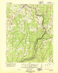 1935 Harviell1943 Print · USGSButler County in the mid-1930s was a landscape of river bends and scattered rural schoolhouses along the St Louis San Francisco Railroad. Genealogists can trace family roots at Black Creek Ch & Cem or locate vanished local schools like Gillis Bluff Sch and Havam Sch.2 unique versions available
 - 1939 Map of Poplar Bluff, 1949 Print
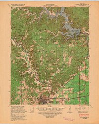 1939 Poplar Bluff1949 Print · USGSSoutheast Missouri’s river-and-rail hub is captured here during the transformative period when the Black River was being dammed. Genealogists can trace family names across a landscape of schools and churches like Baskey Sch, Butler Cem, and Taskee Sta.
End of results
Showing maps 1-3 of 3
Top cities near Poplar Bluff
- Naylor historical maps
- Neelyville historical maps
- Qulin historical maps
- Fisk historical maps
- Williamsville historical maps
Top neighborhoods of Poplar Bluff
- Ashcroft Addition historical maps
- Loma Linda historical maps
- Cedar Valley historical maps
- Kelly Town historical maps
- Vinegar Hill historical maps
Frequently asked questions
- What are the different types of historical maps available for Poplar Bluff?
- What is the oldest map of Poplar Bluff?
- Where can I purchase historical maps of Poplar Bluff for my home or office?
- Where can I download high-res historical maps of Poplar Bluff?
- Are there historical topographic maps available for Poplar Bluff?
- Is there historical aerial imagery available for Poplar Bluff?
- Where are historical maps of Poplar Bluff sourced from?