1960s Maps of Poplar Bluff, Missouri
Explore 6 historic maps of Poplar Bluff from the 1960s. These maps offer a rare glimpse into what life looked like during the 1960s — showing old roads, neighborhoods, homes, and landmarks that have changed or disappeared over time.
Whether you're researching your family's past, planning a metal detecting trip, or studying how Poplar Bluff's landscape evolved across the 1960s, these high-resolution maps are a powerful tool for exploring the history of this region.
- Focus on a specific era: All maps on this page are from the 1960s, giving you a focused view of this time period.
- See what’s changed: Compare century-old streets, trails, and buildings to today's modern landscape using overlays and satellite layers.
- Research with precision: Use these maps for genealogy, historical research, land use analysis, or educational projects.
- View, download, or print: Maps are fully viewable online in high resolution, and can be downloaded or printed for your own records.
Start exploring Poplar Bluff's history through authentic maps from the 1960s. This is your window into the past.
Poplar Bluff, MO maps
(6)- 1960 Map of Poplar Bluff
 1960 Poplar Bluff1960 Print · USGSSoutheast Missouri and Northeast Arkansas are captured here during the post-war era, showing the transition from the Ozark highlands to the Delta. Genealogists and historians can trace rail corridors like the St. Louis Southwestern RR and remote settlements such as Birch Tree and Warm Springs.
 - 1964 Map of Harviell, 1965 Print
 1964 Harviell1965 Print · USGSSouthern Butler County in the mid-sixties reveals a landscape shaped by the Black River and the crossroads at Harviell. Local researchers can trace family roots through numerous sites like Black Creek Ch Cem, Eugene Field Sch, and the Lone Star Ch.3 unique versions available
 - 1964 Map of Harviell, 1968 Print
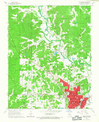
 1964 Harviell1968 Print · USGSButler County in the mid-sixties reveals a landscape defined by the drainage of the Missouri Bootheel and the growth of Poplar Bluff. Genealogists can trace family names at Melton Cem and Kelly Cem or locate vanished rural schoolhouses like Willow Oak Sch.3 unique versions available
 - 1966 Map of Rombauer, 1967 Print
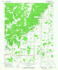 1966 Rombauer1967 Print · USGSButler County in the mid-1960s shows a landscape of timbered national forest and rail-connected prairie settlements. Genealogists and local historians can trace rural family sites at Podesva Cem, Lake Road Sch, and the community centered around Rombauer.2 unique versions available
 - 1966 Map of Poplar Bluff, 1967 Print
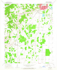
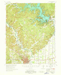
 1966 Poplar Bluff1967 Print · USGSPoplar Bluff and the surrounding Ozark foothills are captured here in the mid-sixties, showing a landscape defined by the BLACK RIVER and the CLARK NATIONAL FOREST. Genealogists can trace family roots through several local burial grounds like Old Mark Twain Cemetery and the Sheppard Cemetery.3 unique versions available
 - 1968 Map of Poplar Bluff, 1970 Print
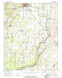
 1968 Poplar Bluff1970 Print · USGSSoutheast Missouri’s river systems and rail hubs are captured here as the region balanced forestry with modern water management. Genealogists can trace family names at Military Crossing Cem, Oak Grove Sch, and rural stops like Hendrickson and Rombauer.
End of results
Showing maps 1-6 of 6
Top cities near Poplar Bluff
- Naylor historical maps
- Neelyville historical maps
- Qulin historical maps
- Fisk historical maps
- Williamsville historical maps
Top neighborhoods of Poplar Bluff
- Ashcroft Addition historical maps
- Loma Linda historical maps
- Cedar Valley historical maps
- Kelly Town historical maps
- Vinegar Hill historical maps
Frequently asked questions
- What are the different types of historical maps available for Poplar Bluff?
- What is the oldest map of Poplar Bluff?
- Where can I purchase historical maps of Poplar Bluff for my home or office?
- Where can I download high-res historical maps of Poplar Bluff?
- Are there historical topographic maps available for Poplar Bluff?
- Is there historical aerial imagery available for Poplar Bluff?
- Where are historical maps of Poplar Bluff sourced from?