1950s Maps of Camdenton, Missouri
Explore 9 historic maps of Camdenton from the 1950s. These maps offer a rare glimpse into what life looked like during the 1950s — showing old roads, neighborhoods, homes, and landmarks that have changed or disappeared over time.
Whether you're researching your family's past, planning a metal detecting trip, or studying how Camdenton's landscape evolved across the 1950s, these high-resolution maps are a powerful tool for exploring the history of this region.
- Focus on a specific era: All maps on this page are from the 1950s, giving you a focused view of this time period.
- See what’s changed: Compare century-old streets, trails, and buildings to today's modern landscape using overlays and satellite layers.
- Research with precision: Use these maps for genealogy, historical research, land use analysis, or educational projects.
- View, download, or print: Maps are fully viewable online in high resolution, and can be downloaded or printed for your own records.
Start exploring Camdenton's history through authentic maps from the 1950s. This is your window into the past.
Camdenton, MO maps
(9)- 1954 Map of Jefferson City
 1954 Jefferson City1954 Print · USGSCentral Missouri in the early postwar years showcases a landscape defined by the winding Lake of the Ozarks and the state capital at Jefferson City. Researchers can trace the mid-century rail networks of the Missouri Pacific RR and locate rural communities like Tuscumbia, St Elizabeth, and St Anthony.2 unique versions available
 - 1954 Map of Springfield
 1954 Springfield1954 Print · USGSThe Missouri Ozarks are captured here during the post-war era, showing the expansion of Springfield and the surrounding river valleys. Genealogists and historians can trace local landmarks like Mount Comfort Cemetery and the Fort Leonard Wood military grounds.6 unique versions available
 - 1955 Map of Jefferson City, 1967 Print
 1955 Jefferson City1967 Print · USGSCentral Missouri in the mid-fifties is defined by the winding Missouri River and the expanding reach of Lake of the Ozarks. Researchers can trace the rail corridors of the Missouri Pacific or locate the early footprint of Whiteman AFB and Jefferson City.4 unique versions available
 - 1958 Map of Jefferson City
 1958 Jefferson City1958 Print · USGSCentral Missouri in the late fifties shows a region transforming through the growth of Whiteman Air Force Base and the Lake of the Ozarks. Researchers can trace rail lines like the Missouri Pacific or find family roots at Enloe Cemetery and Mount Pleasant Cem.
 - 1958 Map of Springfield
 1958 Springfield1958 Print · USGSThe Missouri Ozarks are captured during the mid-century era of growth, centered on the bustling hub of Springfield. Genealogists and historians can trace family roots through numerous landmarks like Ebenezer Church, Stockton Cem, and the various county courthouses.
 - 1959 Map of Jefferson City
 1959 Jefferson City1959 Print · USGSCentral Missouri is captured during the mid-fifties as the river economy and rail networks like the Missouri Pacific met the rise of the automobile. Local researchers can trace family landmarks and rural infrastructure from the Lake of the Ozarks up to Providence Cemetery and Knob Noster State Park.
 - 1959 Map of Springfield
 1959 Springfield1959 Print · USGSThe Missouri Ozarks are captured here during a decade of postwar growth and increasing highway connectivity. Researchers can trace the legacy of the St Louis-San Francisco RR and locate early sites in Springfield, Lebanon, and Mountain Grove.
 - 1959 Map of Camdenton, 1960 Print
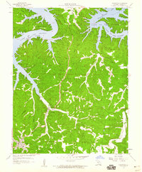 1959 Camdenton1960 Print · USGSCamden County's transition to a reservoir-based economy is clear in the late fifties as Lake of the Ozarks reshapes the landscape. Researchers can trace the migration of local centers through sites like Old Linn Creek, Linn Creek Ch, and Hunter Mine.3 unique versions available
 - 1959 Map of Green Bay Terrace, 1960 Print
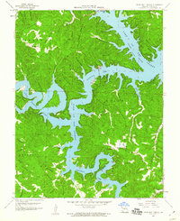 1959 Green Bay Terrace1960 Print · USGSCamden County and the branching waters of the Lake of the Ozarks are shown here in the late fifties, just as the region’s modern recreational identity was taking shape. Genealogists and researchers can locate landmarks like Tick Ridge Cem, Mt Taber Ch, and the well-known Bridal Cave.3 unique versions available
End of results
Showing maps 1-9 of 9
Top cities near Camdenton
- Osage Beach historical maps
- Four Seasons historical maps
- Lake Ozark historical maps
- Laurie historical maps
- Sunrise Beach historical maps
- Linn Creek historical maps
See more
Frequently asked questions
- What are the different types of historical maps available for Camdenton?
- What is the oldest map of Camdenton?
- Where can I purchase historical maps of Camdenton for my home or office?
- Where can I download high-res historical maps of Camdenton?
- Are there historical topographic maps available for Camdenton?
- Is there historical aerial imagery available for Camdenton?
- Where are historical maps of Camdenton sourced from?