Old Maps of Camdenton, Missouri for Genealogy
Trace your family roots with 42 historic maps of Camdenton. These high-res maps reveal old neighborhoods, homesites, landmarks, and streets — helping you uncover where your ancestors lived and how the area evolved over time.
- Explore historic neighborhoods: Identify where your relatives may have lived in the 1800s or 1900s.
- Compare maps over time: Trace the changes in streets, buildings, and landmarks for multi-generational research.
- Perfect for genealogy & ancestry research: Used by family historians and researchers to map out lineage and migration.
These maps are an incredible resource for exploring your personal connection to Camdenton's past.
Camdenton, MO maps
(42)- 1888 Map of Versailles
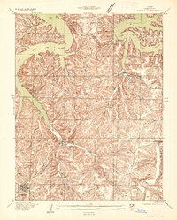
 1888 Versailles1888 Print · USGSCentral Missouri in the late 1880s shows the winding Osage River valley long before the creation of the Lake of the Ozarks. Researchers can trace the original locations of Linn Creek, find the Osage Iron Works, and follow the Missouri Pacific Railroad to its end in Versailles.
 - 1893 Map of Versailles
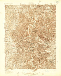
 1893 Versailles1893 Print · USGSCentral Missouri's river-and-rail landscape is captured here in the late nineteenth century, decades before the valley was transformed by dams. Genealogists can trace family roots in early settlements like Versailles, Bagnell, and the original site of Linn Creek.4 unique versions available
 - 1932 Map of Versailles No 4
 1932 Versailles No 41932 Print · USGSThe Missouri Ozarks are captured here in the early 1930s, showing the early transformation of the landscape following the creation of Lake of the Ozarks. Researchers can trace the roots of Osage Beach or locate rural landmarks like Popplewell Cem and Watson Sch.
 - 1933 Map of Stoutland, 1962 Print
 1933 Stoutland1962 Print · USGSThe Missouri Ozarks during the 1930s are captured here as a landscape of isolated hollows and rail-connected towns. Researchers can trace the St Louis San Francisco railroad line through Stoutland or locate family sites like Bradshaw Cem and Merchant Sch.2 unique versions available
 - 1934 Map of Macks Creek
 1934 Macks Creek1934 Print · USGSIn the central Ozarks during the 1930s, the rugged river valleys supported a landscape of isolated homesteads and country schoolhouses. Genealogists can locate family landmarks like Laughlin Cem, Johnston Castle, and the Tunnel Dam along the Niangua River.4 unique versions available
 - 1934 Map of Camdenton
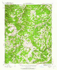
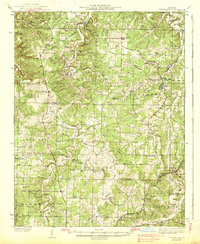
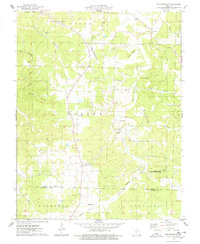
 1934 Camdenton1934 Print · USGSCamden County was undergoing a dramatic transformation in the 1930s as the newly formed lake reshaped the Ozark hills. Genealogists and local historians can trace the early streets of Camdenton and locate rural landmarks like Old Linn Creek Cem and the Anderson Hollow School.
 - 1934 Map of Green Bay Terrace
 1934 Green Bay Terrace1934 Print · USGSCamden County's winding shoreline comes into focus during the mid-1930s as the new reservoir fills the deep hollows of the Ozarks. Genealogists can trace family landmarks like Farmer Cem and Mt Tabor Sch or early riverside retreats like Niangua Colony.2 unique versions available
 - 1938 Map of Stoutland
 1938 Stoutland1938 Print · USGSThe Missouri Ozarks are captured here during the 1930s, showing a landscape of ridge-top farms and creek-bottom settlements. Researchers can trace the heritage of Camden and Laclede counties through sites like Ozark Fisheries, Darrow Cem, and Stoutland.
 - 1939 Map of Macks Creek
 1939 Macks Creek1939 Print · USGSThe Niangua River valley in the late 1930s reveals a landscape of river crossings and early Ozark tourism. Researchers can trace ancestral locations through numerous rural school sites like Barkley Sch or find landmarks like Hahatonka Castle and Tunnel Dam.2 unique versions available
 - 1947 Map of Jefferson City, 1949 Print
 1947 Jefferson City1949 Print · USGSCentral Missouri and the northern Ozarks come into focus in this late 1940s survey of the river-and-rail landscape. Genealogists and historians can trace the growth of Jefferson City and Sedalia or locate family roots near Bagnell Dam and the Lake of the Ozarks.
 - 1954 Map of Jefferson City
 1954 Jefferson City1954 Print · USGSCentral Missouri in the early postwar years showcases a landscape defined by the winding Lake of the Ozarks and the state capital at Jefferson City. Researchers can trace the mid-century rail networks of the Missouri Pacific RR and locate rural communities like Tuscumbia, St Elizabeth, and St Anthony.2 unique versions available
 - 1954 Map of Springfield
 1954 Springfield1954 Print · USGSThe Missouri Ozarks are captured here during the post-war era, showing the expansion of Springfield and the surrounding river valleys. Genealogists and historians can trace local landmarks like Mount Comfort Cemetery and the Fort Leonard Wood military grounds.6 unique versions available
 - 1955 Map of Jefferson City, 1967 Print
 1955 Jefferson City1967 Print · USGSCentral Missouri in the mid-fifties is defined by the winding Missouri River and the expanding reach of Lake of the Ozarks. Researchers can trace the rail corridors of the Missouri Pacific or locate the early footprint of Whiteman AFB and Jefferson City.4 unique versions available
 - 1958 Map of Jefferson City
 1958 Jefferson City1958 Print · USGSCentral Missouri in the late fifties shows a region transforming through the growth of Whiteman Air Force Base and the Lake of the Ozarks. Researchers can trace rail lines like the Missouri Pacific or find family roots at Enloe Cemetery and Mount Pleasant Cem.
 - 1958 Map of Springfield
 1958 Springfield1958 Print · USGSThe Missouri Ozarks are captured during the mid-century era of growth, centered on the bustling hub of Springfield. Genealogists and historians can trace family roots through numerous landmarks like Ebenezer Church, Stockton Cem, and the various county courthouses.
 - 1959 Map of Jefferson City
 1959 Jefferson City1959 Print · USGSCentral Missouri is captured during the mid-fifties as the river economy and rail networks like the Missouri Pacific met the rise of the automobile. Local researchers can trace family landmarks and rural infrastructure from the Lake of the Ozarks up to Providence Cemetery and Knob Noster State Park.
 - 1959 Map of Springfield
 1959 Springfield1959 Print · USGSThe Missouri Ozarks are captured here during a decade of postwar growth and increasing highway connectivity. Researchers can trace the legacy of the St Louis-San Francisco RR and locate early sites in Springfield, Lebanon, and Mountain Grove.
 - 1959 Map of Camdenton, 1960 Print
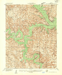
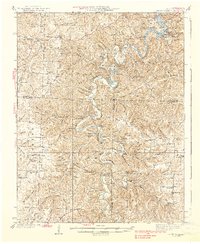
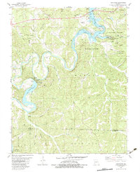
 1959 Camdenton1960 Print · USGSCamden County's transition to a reservoir-based economy is clear in the late fifties as Lake of the Ozarks reshapes the landscape. Researchers can trace the migration of local centers through sites like Old Linn Creek, Linn Creek Ch, and Hunter Mine.3 unique versions available
 - 1959 Map of Green Bay Terrace, 1960 Print
 1959 Green Bay Terrace1960 Print · USGSCamden County and the branching waters of the Lake of the Ozarks are shown here in the late fifties, just as the region’s modern recreational identity was taking shape. Genealogists and researchers can locate landmarks like Tick Ridge Cem, Mt Taber Ch, and the well-known Bridal Cave.3 unique versions available
 - 1975 Map of Decaturville, 1978 Print
 1975 Decaturville1978 Print · USGSThe Missouri Ozarks south of Camdenton appear in the mid-1970s as a region of winding hollows and dispersed rural settlements. Genealogists and local historians can locate several family burial grounds and churches, including Stone Cem, Garrison Cem, and Myetta Ch.
 - 1982 Map of Hahatonka, 1983 Print
 1982 Hahatonka1983 Print · USGSThe Lake of the Ozarks region in the early 1980s reveals a rugged landscape of river bluffs and hydroelectric development. Genealogists and hikers can locate the Ruins and Natural Bridge at Ha Ha Tonka State Park or trace family sites like Dickerson Cem.2 unique versions available
 - 1982 Map of Lebanon, 1983 Print
 1982 Lebanon1983 Print · USGSThe Missouri Ozarks are captured in the early eighties as Interstate 44 and the St Louis-San Francisco rail line link growing towns with the Fort Leonard Wood Military Reservation. Genealogists and historians can trace family-named sites like Flatwood Church and old post offices at Sleeper and Nebo.
 - 1983 Map of Camdenton
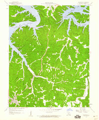
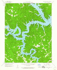
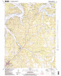 1983 Camdenton1983 Print · USGSCamden County was entering a new era of tourism and development in the early eighties as the lake transformed the Missouri hills. Researchers can trace the relocation of Old Linn Creek and locate several family burial grounds like Zion Cem and Hall Cem.2 unique versions available
 - 1983 Map of Green Bay Terrace
 1983 Green Bay Terrace1983 Print · USGSThe Niangua Arm of the Lake of the Ozarks reached deep into the Ozark hills by the early 1980s, shaping new recreational communities and shoreline landmarks. Genealogists and local historians can locate Farmer Cem, Montgomery Ch, and the rural settlement of Neongwah.2 unique versions available
 - 1983 Map of Lake Of The Ozarks, 1984 Print
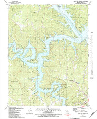
 1983 Lake Of The Ozarks1984 Print · USGSThe Lake of the Ozarks region in the early eighties shows a landscape of deep river bends and growing recreation. Genealogists can trace family names and small settlements from Versailles to Meta and locate old mining sites like Tiff Mine.
Showing maps 1-25 of 42
Top cities near Camdenton
- Osage Beach historical maps
- Four Seasons historical maps
- Lake Ozark historical maps
- Laurie historical maps
- Sunrise Beach historical maps
- Linn Creek historical maps
See more
Frequently asked questions
- What are the different types of historical maps available for Camdenton?
- What is the oldest map of Camdenton?
- Where can I purchase historical maps of Camdenton for my home or office?
- Where can I download high-res historical maps of Camdenton?
- Are there historical topographic maps available for Camdenton?
- Is there historical aerial imagery available for Camdenton?
- Where are historical maps of Camdenton sourced from?