1930s Maps of Passover, Missouri
Explore 2 historic maps of Passover from the 1930s. These maps offer a rare glimpse into what life looked like during the 1930s — showing old roads, neighborhoods, homes, and landmarks that have changed or disappeared over time.
Whether you're researching your family's past, planning a metal detecting trip, or studying how Passover's landscape evolved across the 1930s, these high-resolution maps are a powerful tool for exploring the history of this region.
- Focus on a specific era: All maps on this page are from the 1930s, giving you a focused view of this time period.
- See what’s changed: Compare century-old streets, trails, and buildings to today's modern landscape using overlays and satellite layers.
- Research with precision: Use these maps for genealogy, historical research, land use analysis, or educational projects.
- View, download, or print: Maps are fully viewable online in high resolution, and can be downloaded or printed for your own records.
Start exploring Passover's history through authentic maps from the 1930s. This is your window into the past.
Passover, MO maps
(2)- 1932 Map of Versailles No 4
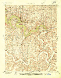
 1932 Versailles No 41932 Print · USGSThe Missouri Ozarks are captured here in the early 1930s, showing the early transformation of the landscape following the creation of Lake of the Ozarks. Researchers can trace the roots of Osage Beach or locate rural landmarks like Popplewell Cem and Watson Sch.
 - 1934 Map of Toronto
 1934 Toronto1934 Print · USGSMissouri's lake country was in its early years of transformation during the 1930s as new shorelines met established rural communities. Genealogists can locate family landmarks like Auglaize Cem or trace rural education at Snider School and Jefferies School.
End of results
Showing maps 1-2 of 2
Top cities near Passover
- Osage Beach historical maps
- Camdenton historical maps
- Four Seasons historical maps
- Lake Ozark historical maps
- Richland historical maps
- Laurie historical maps
See more
Frequently asked questions
- What are the different types of historical maps available for Passover?
- What is the oldest map of Passover?
- Where can I purchase historical maps of Passover for my home or office?
- Where can I download high-res historical maps of Passover?
- Are there historical topographic maps available for Passover?
- Is there historical aerial imagery available for Passover?
- Where are historical maps of Passover sourced from?