1940s Maps of Coal Hill, Missouri
Explore 2 historic maps of Coal Hill from the 1940s. These maps offer a rare glimpse into what life looked like during the 1940s — showing old roads, neighborhoods, homes, and landmarks that have changed or disappeared over time.
Whether you're researching your family's past, planning a metal detecting trip, or studying how Coal Hill's landscape evolved across the 1940s, these high-resolution maps are a powerful tool for exploring the history of this region.
- Focus on a specific era: All maps on this page are from the 1940s, giving you a focused view of this time period.
- See what’s changed: Compare century-old streets, trails, and buildings to today's modern landscape using overlays and satellite layers.
- Research with precision: Use these maps for genealogy, historical research, land use analysis, or educational projects.
- View, download, or print: Maps are fully viewable online in high resolution, and can be downloaded or printed for your own records.
Start exploring Coal Hill's history through authentic maps from the 1940s. This is your window into the past.
Coal Hill, MO maps
(2)- 1941 Map of Tiffin
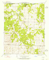
 1941 Tiffin1941 Print · USGSThe rural borderlands of St. Clair and Cedar County come into focus in the years before World War II. Local researchers can trace the locations of numerous vanished schoolhouses like Arrarat Sch and early cemeteries including Union Point Cem and Preston Cem.2 unique versions available
 - 1949 Map of Tiffin, 1955 Print
 1949 Tiffin1955 Print · USGSThe Osage River country in the late 1940s reveals a landscape of isolated farmsteads and rural school districts across the St. Clair and Cedar county line. Genealogists can trace family roots through several landmarks like Landers Cem, Pape Ch, and Arrarat Sch.2 unique versions available
End of results
Showing maps 1-2 of 2
Top cities near Coal Hill
- El Dorado Springs historical maps
- Stockton historical maps
- Osceola historical maps
- Schell City historical maps
- Montevallo historical maps
- Rockville historical maps
See more
Frequently asked questions
- What are the different types of historical maps available for Coal Hill?
- What is the oldest map of Coal Hill?
- Where can I purchase historical maps of Coal Hill for my home or office?
- Where can I download high-res historical maps of Coal Hill?
- Are there historical topographic maps available for Coal Hill?
- Is there historical aerial imagery available for Coal Hill?
- Where are historical maps of Coal Hill sourced from?