1950s Maps of Ashton, Missouri
Explore 3 historic maps of Ashton from the 1950s. These maps offer a rare glimpse into what life looked like during the 1950s — showing old roads, neighborhoods, homes, and landmarks that have changed or disappeared over time.
Whether you're researching your family's past, planning a metal detecting trip, or studying how Ashton's landscape evolved across the 1950s, these high-resolution maps are a powerful tool for exploring the history of this region.
- Focus on a specific era: All maps on this page are from the 1950s, giving you a focused view of this time period.
- See what’s changed: Compare century-old streets, trails, and buildings to today's modern landscape using overlays and satellite layers.
- Research with precision: Use these maps for genealogy, historical research, land use analysis, or educational projects.
- View, download, or print: Maps are fully viewable online in high resolution, and can be downloaded or printed for your own records.
Start exploring Ashton's history through authentic maps from the 1950s. This is your window into the past.
Ashton, MO maps
(3)- 1950 Map of Medill, 1967 Print
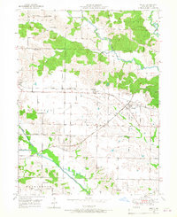 1950 Medill1967 Print · USGSMedill and its neighboring townships are shown here at a mid-century peak of rural rail connectivity and community life. You can trace the crossing of the Chicago Burlington and Quincy and Atchison Topeka and Santa Fe railroads alongside family landmarks like Zimmerman Cem and Happy Hill Sch.2 unique versions available
 - 1951 Map of Medill
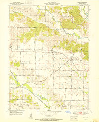 1951 Medill1951 Print · USGSMid-century Clark County is defined here by its intersection of major rail lines and a thriving network of rural schools and churches. Genealogists can trace family footprints through sites like Zimmerman Cem, Happy Hill Sch, and Carmel Ch.
 - 1958 Map of Burlington, 1968 Print
 1958 Burlington1968 Print · USGSThe tri-state river country of Iowa, Illinois, and Missouri is captured here in the mid-fifties, dominated by the Mississippi River and major rail lines. Genealogists and historians can trace the development of river towns like Keokuk or locate the sprawling Iowa Army Ammunition Plant.4 unique versions available
End of results
Showing maps 1-3 of 3
Top cities near Ashton
- Kahoka historical maps
- Donnellson historical maps
- Farmington historical maps
- Wayland historical maps
- Wyaconda historical maps
- Revere historical maps
See more
Frequently asked questions
- What are the different types of historical maps available for Ashton?
- What is the oldest map of Ashton?
- Where can I purchase historical maps of Ashton for my home or office?
- Where can I download high-res historical maps of Ashton?
- Are there historical topographic maps available for Ashton?
- Is there historical aerial imagery available for Ashton?
- Where are historical maps of Ashton sourced from?