1980s Maps of Guyton, Missouri
Explore 2 historic maps of Guyton from the 1980s. These maps offer a rare glimpse into what life looked like during the 1980s — showing old roads, neighborhoods, homes, and landmarks that have changed or disappeared over time.
Whether you're researching your family's past, planning a metal detecting trip, or studying how Guyton's landscape evolved across the 1980s, these high-resolution maps are a powerful tool for exploring the history of this region.
- Focus on a specific era: All maps on this page are from the 1980s, giving you a focused view of this time period.
- See what’s changed: Compare century-old streets, trails, and buildings to today's modern landscape using overlays and satellite layers.
- Research with precision: Use these maps for genealogy, historical research, land use analysis, or educational projects.
- View, download, or print: Maps are fully viewable online in high resolution, and can be downloaded or printed for your own records.
Start exploring Guyton's history through authentic maps from the 1980s. This is your window into the past.
Guyton, MO maps
(2)- 1984 Map of Lathrop
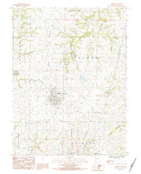 1984 Lathrop1984 Print · USGSClinton County’s agricultural heartland is documented in the mid-1980s, centering on the grid of Lathrop and its surrounding farmstead infrastructure. Researchers can trace local burial sites at Bethel Cem or follow the waters of Little Shoal Creek and the Crooked River.
 - 1986 Map of Saint Joseph
 1986 Saint Joseph1986 Print · USGSNorthwest Missouri thrived as a regional transportation and educational hub during the mid-eighties, centered on the historic river city of Saint Joseph. Researchers can locate specific local landmarks like Burlington Cemetery, Pigeon Hill Church, and the winding Pony Express Trail.2 unique versions available
End of results
Showing maps 1-2 of 2
Top cities near Guyton
- Kansas City historical maps
- Liberty historical maps
- Excelsior Springs historical maps
- Kearney historical maps
- Smithville historical maps
- Cameron historical maps
See more
Frequently asked questions
- What are the different types of historical maps available for Guyton?
- What is the oldest map of Guyton?
- Where can I purchase historical maps of Guyton for my home or office?
- Where can I download high-res historical maps of Guyton?
- Are there historical topographic maps available for Guyton?
- Is there historical aerial imagery available for Guyton?
- Where are historical maps of Guyton sourced from?