1960s Maps of Jefferson City, Missouri
Explore 3 historic maps of Jefferson City from the 1960s. These maps offer a rare glimpse into what life looked like during the 1960s — showing old roads, neighborhoods, homes, and landmarks that have changed or disappeared over time.
Whether you're researching your family's past, planning a metal detecting trip, or studying how Jefferson City's landscape evolved across the 1960s, these high-resolution maps are a powerful tool for exploring the history of this region.
- Focus on a specific era: All maps on this page are from the 1960s, giving you a focused view of this time period.
- See what’s changed: Compare century-old streets, trails, and buildings to today's modern landscape using overlays and satellite layers.
- Research with precision: Use these maps for genealogy, historical research, land use analysis, or educational projects.
- View, download, or print: Maps are fully viewable online in high resolution, and can be downloaded or printed for your own records.
Start exploring Jefferson City's history through authentic maps from the 1960s. This is your window into the past.
Jefferson City, MO maps
(3)- 1967 Map of Osage City, 1968 Print
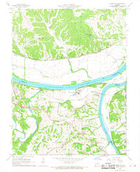 1967 Osage City1968 Print · USGSMid-Missouri river life and rail transit converge in the late sixties at the meeting of the Missouri River and Osage River. Researchers can trace the heritage of Osage City and Taos, or locate family sites like St Xaviers Cem and Link Cem.4 unique versions available
 - 1967 Map of Jefferson City, 1968 Print
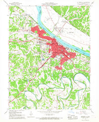 1967 Jefferson City1968 Print · USGSJefferson City and the Missouri River corridor are captured in the late 1960s, showing the capital's expansion and its deep-rooted rail infrastructure. Researchers can locate specific institutional sites like the State Penitentiary, Lincoln University, and several historic burying grounds such as St Peters Cem.4 unique versions available
 - 1968 Map of Lohman, 1971 Print
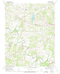 1968 Lohman1971 Print · USGSCole County hill country at the end of the sixties shows a transition from quiet agricultural roots to modern recreation and expansion. Genealogists can trace family heritage at Old Catholic Cem, St Pauls Ch, and the rural crossroads of Lohman.3 unique versions available
End of results
Showing maps 1-3 of 3
Top cities near Jefferson City
- Holts Summit historical maps
- Ashland historical maps
- Wardsville historical maps
- Taos historical maps
- New Bloomfield historical maps
- Lake Mykee Town historical maps
See more
Top neighborhoods of Jefferson City
Frequently asked questions
- What are the different types of historical maps available for Jefferson City?
- What is the oldest map of Jefferson City?
- Where can I purchase historical maps of Jefferson City for my home or office?
- Where can I download high-res historical maps of Jefferson City?
- Are there historical topographic maps available for Jefferson City?
- Is there historical aerial imagery available for Jefferson City?
- Where are historical maps of Jefferson City sourced from?