Old Maps of Wardsville, Missouri
Explore 27 old maps of Wardsville, spanning from 1886 to today. These high-resolution historic maps reveal how streets, neighborhoods, landmarks, and natural features evolved over time — perfect for genealogy, metal detecting, research, and local history exploration.
What you can do with these maps:
- See how Wardsville changed over time: Compare historical maps to modern-day views to trace roads, homesites, rail lines & more.
- View detailed metadata: Each map includes creators, publishers, year, scale, and archive source.
- Overlay maps with satellite & LiDAR: Visualize the past alongside modern tools to explore terrain & human change.
- Trusted historical sources: Maps sourced from the USGS, Library of Congress, and other archives.
- Access maps your way: View online, download high-res files, or order prints for personal or research use.
Start exploring old maps of Wardsville to uncover forgotten places, hidden landmarks, and the deep history beneath your feet.
Wardsville, MO maps
(27)- 1886 Map of Jefferson City
 1886 Jefferson City1886 Print · USGSMid-Missouri was a bustling corridor of river traffic and rail expansion during the 1880s. You can trace the early tracks of the Missouri Pacific Railroad and locate vanished river landings like Nashville or Providence along the winding Missouri River.
 - 1888 Map of Tuscumbia
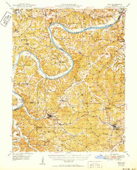
 1888 Tuscumbia1888 Print · USGSThe Osage River valley comes to life in the 1880s, showcasing the intricate river bends and rugged hills of central Missouri. Genealogists and researchers can trace the original locations of early settlements like Tuscumbia, St. Elizabeth, and Iberia.
 - 1894 Map of Tuscumbia
 1894 Tuscumbia1894 Print · USGSCentral Missouri's river-and-rail landscape is captured here in the 1890s as the Osage River served as the region's main artery. Genealogists and historians can trace the early boundaries of communities like Tuscumbia, St. Elizabeth, and Iberia.3 unique versions available
 - 1894 Map of Jefferson City
 1894 Jefferson City1894 Print · USGSMid-Missouri during the late nineteenth century was a landscape of river landings and burgeoning rail towns. Genealogists and historians can trace early track layouts of the Missouri Pacific Railroad and locate interior settlements like Ashland, Millersburg, and Centretown.4 unique versions available
 - 1939 Map of Jefferson City
 1939 Jefferson City1939 Print · USGSJefferson City and the winding Moreau River are captured here in the late thirties, showing the Missouri state capital as it functioned before mid-century expansion. Genealogists can locate family landmarks like Shumate Chapel Cem, the Lincoln Institute, and rural outposts like Grays.2 unique versions available
 - 1939 Map of Jefferson City, 1954 Print
 1939 Jefferson City1954 Print · USGSMissouri's capital and the surrounding river bluffs are captured here in the late thirties, showing the region's transition between rural farmland and state governance. Researchers can locate family landmarks like Providence Cem, the Algoa Reformatory, and various schools such as Sycamore Sch.2 unique versions available
 - 1942 Map of Jefferson City
 1942 Jefferson City1942 Print · USGSJefferson City and the surrounding river bluffs are captured in the early years of the war, when rail travel and state agriculture dominated the landscape. Genealogists can locate family-named landmarks and rural schools like Hall Sch, Williams Cem, and the small settlement of New Bloomfield.2 unique versions available
 - 1947 Map of Jefferson City, 1949 Print
 1947 Jefferson City1949 Print · USGSCentral Missouri and the northern Ozarks come into focus in this late 1940s survey of the river-and-rail landscape. Genealogists and historians can trace the growth of Jefferson City and Sedalia or locate family roots near Bagnell Dam and the Lake of the Ozarks.
 - 1948 Map of Meta, 1963 Print
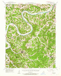 1948 Meta1963 Print · USGSThe Osage River valley in the late 1940s shows a landscape of river ferries and emerging rail hubs. Researchers can trace family sites like St Cecilia Cem & Ch, early river infrastructure at the US Lock & Dam, and rural centers such as Koeltztown.
 - 1950 Map of Meta
 1950 Meta1950 Print · USGSMid-century life in the Missouri river hills centers on the winding Osage River and the small parish towns of the interior. Genealogists can trace family roots through several rural schools and burial grounds, including St Cecelia Cem and the Bodie Ferry (Aban'd).
 - 1954 Map of Jefferson City
 1954 Jefferson City1954 Print · USGSCentral Missouri in the early postwar years showcases a landscape defined by the winding Lake of the Ozarks and the state capital at Jefferson City. Researchers can trace the mid-century rail networks of the Missouri Pacific RR and locate rural communities like Tuscumbia, St Elizabeth, and St Anthony.2 unique versions available
 - 1955 Map of Jefferson City, 1967 Print
 1955 Jefferson City1967 Print · USGSCentral Missouri in the mid-fifties is defined by the winding Missouri River and the expanding reach of Lake of the Ozarks. Researchers can trace the rail corridors of the Missouri Pacific or locate the early footprint of Whiteman AFB and Jefferson City.4 unique versions available
 - 1958 Map of Jefferson City
 1958 Jefferson City1958 Print · USGSCentral Missouri in the late fifties shows a region transforming through the growth of Whiteman Air Force Base and the Lake of the Ozarks. Researchers can trace rail lines like the Missouri Pacific or find family roots at Enloe Cemetery and Mount Pleasant Cem.
 - 1959 Map of Jefferson City
 1959 Jefferson City1959 Print · USGSCentral Missouri is captured during the mid-fifties as the river economy and rail networks like the Missouri Pacific met the rise of the automobile. Local researchers can trace family landmarks and rural infrastructure from the Lake of the Ozarks up to Providence Cemetery and Knob Noster State Park.
 - 1967 Map of Jefferson City, 1968 Print
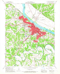 1967 Jefferson City1968 Print · USGSJefferson City and the Missouri River corridor are captured in the late 1960s, showing the capital's expansion and its deep-rooted rail infrastructure. Researchers can locate specific institutional sites like the State Penitentiary, Lincoln University, and several historic burying grounds such as St Peters Cem.4 unique versions available
 - 1980 Map of Jefferson City, 1981 Print
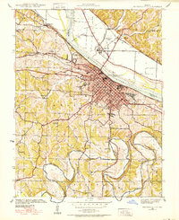
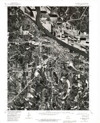 1980 Jefferson City1981 Print · USGSJefferson City and the Missouri River valley are captured in this 1980 orthophoto just as the capital's suburban footprint was expanding. Researchers can trace the industrial riverfront near the Capitol or locate outlying communities like Cole Junction and Wardsville.
 - 1982 Map of Jefferson City, 1983 Print
 1982 Jefferson City1983 Print · USGSMid-Missouri in the early eighties shows the corridor between Columbia and Jefferson City during a period of modern growth. Genealogists and historians can trace the Missouri Pacific Railroad route, family plots at Memorial Park Cem, and landmarks like Osage City and Lupus.
 - 1983 Map of Lake Of The Ozarks, 1984 Print
 1983 Lake Of The Ozarks1984 Print · USGSThe Lake of the Ozarks region in the early eighties shows a landscape of deep river bends and growing recreation. Genealogists can trace family names and small settlements from Versailles to Meta and locate old mining sites like Tiff Mine.
 - 1987 Map of Wardsville, 1988 Print
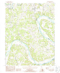 1987 Wardsville1988 Print · USGSThe winding Osage River corridor comes into focus in the late 1980s, revealing a landscape of upland farms and riverbank forests. Trace family roots and local landmarks from Wardsville to Osage Bend, and explore the grounds of Painted Rock State Forest.
 - 2011 Map of Wardsville, 2011 Print
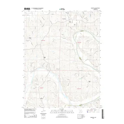
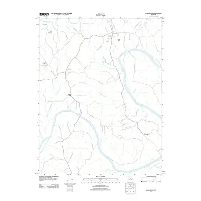 2011 Wardsville2011 Print · USGSCovers Wardsville, including Honey Creek, Osage Bluff, and other nearby areas
 - 2011 Map of Jefferson City, 2011 Print
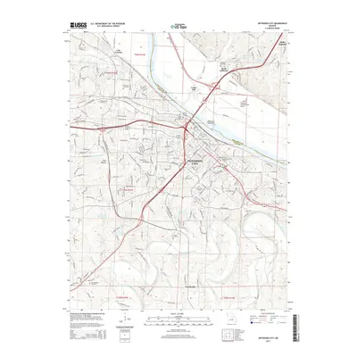
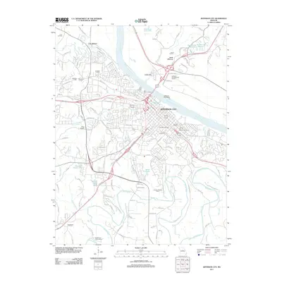 2011 Jefferson City2011 Print · USGSCovers Wardsville, including Jefferson City, Holts Summit, and other nearby areas
 - 2015 Map of Wardsville, 2015 Print
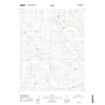
 2015 Wardsville2015 Print · USGSCovers Wardsville, including Honey Creek, Osage Bluff, and other nearby areas
 - 2015 Map of Jefferson City, 2015 Print
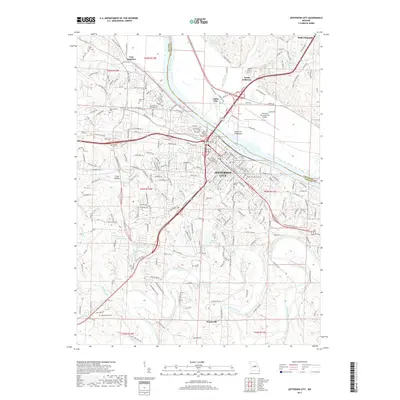
 2015 Jefferson City2015 Print · USGSCovers Wardsville, including Jefferson City, Holts Summit, and other nearby areas
 - 2017 Map of Wardsville, 2017 Print
 2017 Wardsville2017 Print · USGSCovers Wardsville, including Honey Creek, Osage Bluff, and other nearby areas
 - 2017 Map of Jefferson City, 2017 Print
 2017 Jefferson City2017 Print · USGSCovers Wardsville, including Jefferson City, Holts Summit, and other nearby areas
Showing maps 1-25 of 27
Top cities near Wardsville
- Jefferson City historical maps
- Holts Summit historical maps
- Taos historical maps
- New Bloomfield historical maps
- Lake Mykee Town historical maps
- Westphalia historical maps
See more
Frequently asked questions
- What are the different types of historical maps available for Wardsville?
- What is the oldest map of Wardsville?
- Where can I purchase historical maps of Wardsville for my home or office?
- Where can I download high-res historical maps of Wardsville?
- Are there historical topographic maps available for Wardsville?
- Is there historical aerial imagery available for Wardsville?
- Where are historical maps of Wardsville sourced from?