1980s Maps of Wardsville, Missouri
Explore 4 historic maps of Wardsville from the 1980s. These maps offer a rare glimpse into what life looked like during the 1980s — showing old roads, neighborhoods, homes, and landmarks that have changed or disappeared over time.
Whether you're researching your family's past, planning a metal detecting trip, or studying how Wardsville's landscape evolved across the 1980s, these high-resolution maps are a powerful tool for exploring the history of this region.
- Focus on a specific era: All maps on this page are from the 1980s, giving you a focused view of this time period.
- See what’s changed: Compare century-old streets, trails, and buildings to today's modern landscape using overlays and satellite layers.
- Research with precision: Use these maps for genealogy, historical research, land use analysis, or educational projects.
- View, download, or print: Maps are fully viewable online in high resolution, and can be downloaded or printed for your own records.
Start exploring Wardsville's history through authentic maps from the 1980s. This is your window into the past.
Wardsville, MO maps
(4)- 1980 Map of Jefferson City, 1981 Print
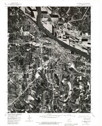 1980 Jefferson City1981 Print · USGSJefferson City and the Missouri River valley are captured in this 1980 orthophoto just as the capital's suburban footprint was expanding. Researchers can trace the industrial riverfront near the Capitol or locate outlying communities like Cole Junction and Wardsville.
 - 1982 Map of Jefferson City, 1983 Print
 1982 Jefferson City1983 Print · USGSMid-Missouri in the early eighties shows the corridor between Columbia and Jefferson City during a period of modern growth. Genealogists and historians can trace the Missouri Pacific Railroad route, family plots at Memorial Park Cem, and landmarks like Osage City and Lupus.
 - 1983 Map of Lake Of The Ozarks, 1984 Print
 1983 Lake Of The Ozarks1984 Print · USGSThe Lake of the Ozarks region in the early eighties shows a landscape of deep river bends and growing recreation. Genealogists can trace family names and small settlements from Versailles to Meta and locate old mining sites like Tiff Mine.
 - 1987 Map of Wardsville, 1988 Print
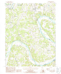 1987 Wardsville1988 Print · USGSThe winding Osage River corridor comes into focus in the late 1980s, revealing a landscape of upland farms and riverbank forests. Trace family roots and local landmarks from Wardsville to Osage Bend, and explore the grounds of Painted Rock State Forest.
End of results
Showing maps 1-4 of 4
Top cities near Wardsville
- Jefferson City historical maps
- Holts Summit historical maps
- Taos historical maps
- New Bloomfield historical maps
- Lake Mykee Town historical maps
- Westphalia historical maps
See more
Frequently asked questions
- What are the different types of historical maps available for Wardsville?
- What is the oldest map of Wardsville?
- Where can I purchase historical maps of Wardsville for my home or office?
- Where can I download high-res historical maps of Wardsville?
- Are there historical topographic maps available for Wardsville?
- Is there historical aerial imagery available for Wardsville?
- Where are historical maps of Wardsville sourced from?