1930s Maps of Limberlost, Missouri
Explore 3 historic maps of Limberlost from the 1930s. These maps offer a rare glimpse into what life looked like during the 1930s — showing old roads, neighborhoods, homes, and landmarks that have changed or disappeared over time.
Whether you're researching your family's past, planning a metal detecting trip, or studying how Limberlost's landscape evolved across the 1930s, these high-resolution maps are a powerful tool for exploring the history of this region.
- Focus on a specific era: All maps on this page are from the 1930s, giving you a focused view of this time period.
- See what’s changed: Compare century-old streets, trails, and buildings to today's modern landscape using overlays and satellite layers.
- Research with precision: Use these maps for genealogy, historical research, land use analysis, or educational projects.
- View, download, or print: Maps are fully viewable online in high resolution, and can be downloaded or printed for your own records.
Start exploring Limberlost's history through authentic maps from the 1930s. This is your window into the past.
Limberlost, MO maps
(3)- 1932 Map of Steelville
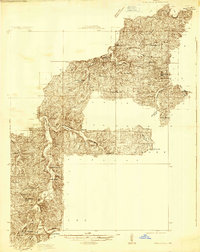 1932 Steelville1932 Print · USGSCrawford County's river valleys and rail junctions are documented here during the early 1930s. Genealogists and historians can locate rural landmarks like Frazier Cem, the St Louis-San Francisco rail line, and numerous schools such as Liberty Sch.
 - 1933 Map of Steelville, 1966 Print
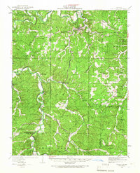 1933 Steelville1966 Print · USGSCrawford County at the start of the 1930s is a landscape of river-valley settlements and rural industry. Genealogists can trace family lines through dozens of country schools and cemeteries, from Oak Ridge Sch to the Wilkinson Cem near Cherryville.
 - 1937 Map of Steelville
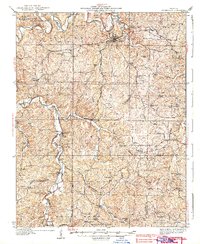 1937 Steelville1937 Print · USGSCrawford County in the mid-1930s centered on the rail-and-river life of the Steelville area. Researchers can trace early rural life through a detailed network of landmarks like Sligo, Cook Station, and Indian Trail State Park.3 unique versions available
End of results
Showing maps 1-3 of 3
Top cities near Limberlost
Frequently asked questions
- What are the different types of historical maps available for Limberlost?
- What is the oldest map of Limberlost?
- Where can I purchase historical maps of Limberlost for my home or office?
- Where can I download high-res historical maps of Limberlost?
- Are there historical topographic maps available for Limberlost?
- Is there historical aerial imagery available for Limberlost?
- Where are historical maps of Limberlost sourced from?